IMAGES TAKEN NEAR TO
The Birches, LEEDS, LS20 9EH
Introduction
This page details the photographs taken nearby to The Birches, LS20 9EH by members of the Geograph project.
The Geograph project started in 2005 with the aim of publishing, organising and preserving representative images for every square kilometre of Great Britain, Ireland and the Isle of Man.

There are currently over 7.5m images from over14,400 individuals and you can help contribute to the project by visiting https://www.geograph.org.uk
Image Map (Loading...)


Getting Data...Please wait
Leaflet Map data © OpenStreetMap
Images are licensed for reuse under creativecommons.org/licenses/by-sa/2.0
Notes
- Clicking on the map will re-center to the selected point.
- The higher the marker number, the further away the image location is from the centre of the postcode.
Image Listing (162 Images Found)
Images are licensed for reuse under creativecommons.org/licenses/by-sa/2.0
Image
Details
Distance
4
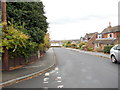
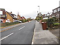
The Sycamores - viewed from The Beeches
Image: © Betty Longbottom
Taken: 13 Nov 2012
0.04 miles
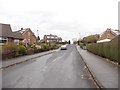
7
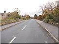
The Sycamores - viewed from The Beeches
Image: © Betty Longbottom
Taken: 13 Nov 2012
0.05 miles
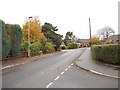
8
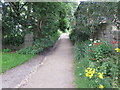
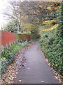
Public Footpath from West Villa Road to Kelcliffe in Guiseley
Looking north-westward.
Image: © Peter Wood
Taken: 1 Aug 2017
0.06 miles
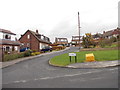
9
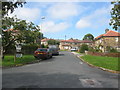
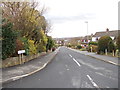
Moorland Crescent
From the junction with Moorland Avenue
Image: © Stephen Armstrong
Taken: 10 Sep 2010
0.06 miles