IMAGES TAKEN NEAR TO
Ghyll Royd, LEEDS, LS20 9BP
Introduction
This page details the photographs taken nearby to Ghyll Royd, LS20 9BP by members of the Geograph project.
The Geograph project started in 2005 with the aim of publishing, organising and preserving representative images for every square kilometre of Great Britain, Ireland and the Isle of Man.

There are currently over 7.5m images from over14,400 individuals and you can help contribute to the project by visiting https://www.geograph.org.uk
Image Map
Images are licensed for reuse under creativecommons.org/licenses/by-sa/2.0
Notes
- Clicking on the map will re-center to the selected point.
- The higher the marker number, the further away the image location is from the centre of the postcode.
Image Listing (132 Images Found)
Images are licensed for reuse under creativecommons.org/licenses/by-sa/2.0
Image
Details
Distance
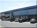
3
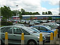
West Side Retail Park, Guiseley
The bigger of the two retail parks in Guiseley.
Image: © Mark Morton
Taken: 29 May 2005
0.04 miles
4
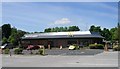
McDonald's - West Side Retail Park
Image: © Betty Longbottom
Taken: 30 Jun 2010
0.04 miles
5
Argos Extra - West Side Retail Park
Image: © Betty Longbottom
Taken: 30 Jun 2010
0.05 miles
6
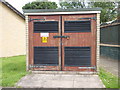
Electricity Substation No 5162 - Leeds Road
Image: © Betty Longbottom
Taken: 9 Jul 2012
0.05 miles
10
Carpet Right - West Side Retail Park
Image: © Betty Longbottom
Taken: 30 Jun 2010
0.07 miles