IMAGES TAKEN NEAR TO
Highway, LEEDS, LS20 8LF
Introduction
This page details the photographs taken nearby to Highway, LS20 8LF by members of the Geograph project.
The Geograph project started in 2005 with the aim of publishing, organising and preserving representative images for every square kilometre of Great Britain, Ireland and the Isle of Man.

There are currently over 7.5m images from over14,400 individuals and you can help contribute to the project by visiting https://www.geograph.org.uk
Image Map
Images are licensed for reuse under creativecommons.org/licenses/by-sa/2.0
Notes
- Clicking on the map will re-center to the selected point.
- The higher the marker number, the further away the image location is from the centre of the postcode.
Image Listing (47 Images Found)
Images are licensed for reuse under creativecommons.org/licenses/by-sa/2.0
Image
Details
Distance
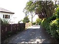
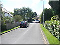
5
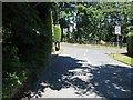
Moorway joining Thorpe Lane at Tranmere Park
Looking north-westward to the gated footpath entrance to Thorpe Farm.
Image: © Peter Wood
Taken: 27 Jun 2018
0.07 miles
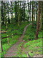
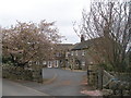
8
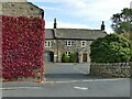
The former Thorpe Farm
The farm is now a small business park, but the site has a long history, being mentioned from the 14th century onwards, as "Thorpe or Little Hawksworth". The main farm building here dates from the 17th century and is Grade II listed. (list entry 1253267).
The reason for it ceasing to be a working farm may be connected with the former High Royds mental hospital nearby, as explained in the following text found online (source - http://www.highroydshospital.com/insight/farming-the-land-g-w-bitton/ ):
"The site of High Royds in the rich Yorkshire countryside of Lower Wharfedale, and the importance given from the very earliest days to the concept of a self-sufficient community, meant that farming and the needs of the land were a central feature of life in the institution. In total there were four separate farms – Thorpe, Norcroft, Odda and Home Farm – with over 600 acres of land. Local men were employed to do much of the farm labour, and were paid an extra supplement for working alongside the patients. Tasks undertaken by patients were usually fetching and carrying churns of milk and sacks of grain, as well as helping to look after the animals. ... The pigs and milk were at Holme Farm, rearing stock at Norcroft, older stock at Odda and dried off cows at Thorpe until they came into milk again."
Image: © Stephen Craven
Taken: 26 Sep 2020
0.11 miles
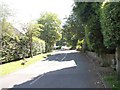
10
Thorpe Farm
Now Hawksworth Estate Cortyard Buildings
Image: © John Slater
Taken: 6 Apr 2017
0.12 miles