IMAGES TAKEN NEAR TO
Fieldhead Road, LEEDS, LS20 8DU
Introduction
This page details the photographs taken nearby to Fieldhead Road, LS20 8DU by members of the Geograph project.
The Geograph project started in 2005 with the aim of publishing, organising and preserving representative images for every square kilometre of Great Britain, Ireland and the Isle of Man.

There are currently over 7.5m images from over14,400 individuals and you can help contribute to the project by visiting https://www.geograph.org.uk
Image Map
Images are licensed for reuse under creativecommons.org/licenses/by-sa/2.0
Notes
- Clicking on the map will re-center to the selected point.
- The higher the marker number, the further away the image location is from the centre of the postcode.
Image Listing (59 Images Found)
Images are licensed for reuse under creativecommons.org/licenses/by-sa/2.0
Image
Details
Distance
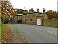
3
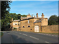
Former estate buildings, Park Road, Guiseley
The original boundary wall of Esholt estate near Old Hollins Hill.
Image: © David Spencer
Taken: 21 Aug 2005
0.09 miles
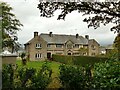
6
Park Gate House, Guiseley
According to the local history society, the house is mentioned as early as 1625 although the present building dates from c.1725-1735, extended c.1860 by Sir Matthew William Thompson. The house is listed grade II (list entry 1251079) and is now divided into apartments. This is the read view from Park Road. Compare Image taken in 2005.
Source: http://www.aireboroughhistoricalsociety.co.uk/guiseley/parkgate.aspx
Image: © Stephen Craven
Taken: 24 Oct 2020
0.11 miles
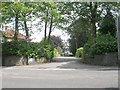
7
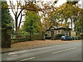
Park Gate Lodge, Park Road, Guiseley
A late 19th century lodge to the 18th century Park Gate House Image It is separately listed (grade II, entry 1261885, including the gates and piers).
Image: © Stephen Craven
Taken: 24 Oct 2020
0.12 miles
8
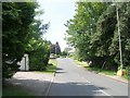
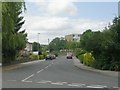
The top of Old Hollings Hill
This is the Guiseley end of the road. The other end of the road at Esholt Image is called Old Hollins Hill (note the difference in spelling - I don't know where it changes).
Image: © Stephen Craven
Taken: 24 Oct 2020
0.12 miles
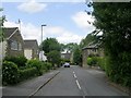
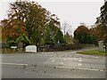
10
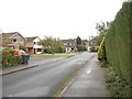
Fieldhead Road - Hawksworth Avenue
Image: © Betty Longbottom
Taken: 3 Jul 2010
0.13 miles