IMAGES TAKEN NEAR TO
Otley Road, LEEDS, LS20 8AF
Introduction
This page details the photographs taken nearby to Otley Road, LS20 8AF by members of the Geograph project.
The Geograph project started in 2005 with the aim of publishing, organising and preserving representative images for every square kilometre of Great Britain, Ireland and the Isle of Man.

There are currently over 7.5m images from over14,400 individuals and you can help contribute to the project by visiting https://www.geograph.org.uk
Image Map (Loading...)


Getting Data...Please wait
Leaflet Map data © OpenStreetMap
Images are licensed for reuse under creativecommons.org/licenses/by-sa/2.0
Notes
- Clicking on the map will re-center to the selected point.
- The higher the marker number, the further away the image location is from the centre of the postcode.
Image Listing (288 Images Found)
Images are licensed for reuse under creativecommons.org/licenses/by-sa/2.0
Image
Details
Distance
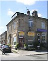
2
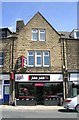
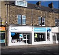
Guiseley Osteopathic Centre - Otley Road
Image: © Betty Longbottom
Taken: 30 Jun 2010
0.01 miles
6
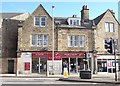
Wharfedale Equestrian - Oxford Road
Image: © Betty Longbottom
Taken: 2 Nov 2012
0.02 miles
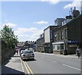
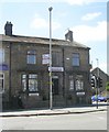
7
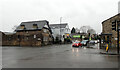
Junction of Victoria Road, Otley Road (A65) and Oxford Road, Guiseley
Image: © habiloid
Taken: 5 Feb 2022
0.02 miles
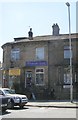
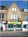
8
Sue Ryder Charity Shop - Wheatfields Hospice - Otley Road
Image: © Betty Longbottom
Taken: 2 Nov 2012
0.02 miles