IMAGES TAKEN NEAR TO
St. Johns Drive, LEEDS, LS19 7NB
Introduction
This page details the photographs taken nearby to St. Johns Drive, LS19 7NB by members of the Geograph project.
The Geograph project started in 2005 with the aim of publishing, organising and preserving representative images for every square kilometre of Great Britain, Ireland and the Isle of Man.

There are currently over 7.5m images from over14,400 individuals and you can help contribute to the project by visiting https://www.geograph.org.uk
Image Map
Images are licensed for reuse under creativecommons.org/licenses/by-sa/2.0
Notes
- Clicking on the map will re-center to the selected point.
- The higher the marker number, the further away the image location is from the centre of the postcode.
Image Listing (132 Images Found)
Images are licensed for reuse under creativecommons.org/licenses/by-sa/2.0
Image
Details
Distance
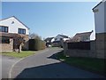
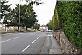
2
St John's Road - viewed from St John's Drive
Image: © Betty Longbottom
Taken: 27 Mar 2012
0.05 miles
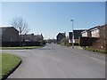
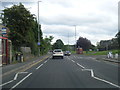
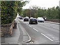
3
St John's Drive, Yeadon
Seen from the corner of New Road (the A65).
Image: © Rich Tea
Taken: 29 Aug 2020
0.05 miles
6
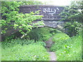
Dismantled Railway Line under St Johns Road, Yeadon
There used to be a branch line from Esholt Junction (near Guiseley) to Yeadon. The line is regularly walked by dog lovers and others.
Image: © Mark Morton
Taken: 23 May 2005
0.06 miles
7
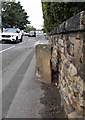
Milestone on New Road, Yeadon
This milestone is on New Road (the A65), less than 10 metres south-east of the junction with St John's Drive (which can be seen just beyond the milestone). It was probably erected when the Leeds to Guiseley Turnpike was developed in the 1830's. It marks a point 7 miles from City Square in Leeds City Centre, and is one of 5 similar milestones along the road.
Image: © Rich Tea
Taken: 29 Aug 2020
0.07 miles
8
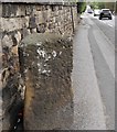
Milestone on New Road, Yeadon
This milestone is on New Road (the A65), less than 10 metres south-east of the junction with St John's Drive (which was just behind me). It was probably erected when the Leeds to Guiseley Turnpike was developed in the 1830's. It marks a point 8 miles from City Square in Leeds City Centre, and is one of 5 similar milestones along the road.
Milestone Society National ID: YW_LEBU08
Image: © Rich Tea
Taken: 29 Aug 2020
0.07 miles
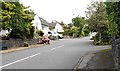
9
New Road, Yeadon
Looking towards Image, with the junction of St John's Drive just beyond the milestone.
Image: © Rich Tea
Taken: 29 Aug 2020
0.07 miles
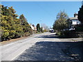
10
New Road, Yeadon
Looking down New Road (the A65) from the junction of St John's Drive. Image can be seen against the wall.
Image: © Rich Tea
Taken: 29 Aug 2020
0.07 miles