IMAGES TAKEN NEAR TO
Redwood Way, LEEDS, LS19 7JU
Introduction
This page details the photographs taken nearby to Redwood Way, LS19 7JU by members of the Geograph project.
The Geograph project started in 2005 with the aim of publishing, organising and preserving representative images for every square kilometre of Great Britain, Ireland and the Isle of Man.

There are currently over 7.5m images from over14,400 individuals and you can help contribute to the project by visiting https://www.geograph.org.uk
Image Map
Images are licensed for reuse under creativecommons.org/licenses/by-sa/2.0
Notes
- Clicking on the map will re-center to the selected point.
- The higher the marker number, the further away the image location is from the centre of the postcode.
Image Listing (106 Images Found)
Images are licensed for reuse under creativecommons.org/licenses/by-sa/2.0
Image
Details
Distance
3
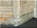
Yeadon, 38 Kirk Lane
This property has been a retail outlet, but has now been converted to a private residence. The doorway has been bricked up, but on the right hand doorpost is a benchmark cut about 1 foot from ground level.
Image: © Mel Towler
Taken: 7 Aug 2021
0.05 miles
4
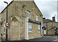
Yeadon, 38 Kirk Lane
A wider angle showing the south facing front of the property. This property has been a retail outlet, but has now been converted to a private residence. The doorway has been bricked up. The supports for the shop display window are still present on the south facing all. On the right hand doorpost is a benchmark cut about 1 foot from ground level.
Image: © Mel Towler
Taken: 7 Aug 2021
0.05 miles
6
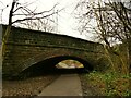
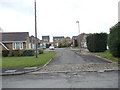
New Road bridge over the Yeadon Cycleway
The cycleway runs for 1.3km from Engine Fields to Ghyll Royd and follows most of the length of the former Yeadon branch of the Midland Railway that closed in 1964. The original cutting must have been partly infilled, as there certainly isn't room for a standard gauge train to fit under the bridge at the present ground level. New Road is the main A65 Leeds to Kendal road.
Image: © Stephen Craven
Taken: 24 Jan 2021
0.06 miles
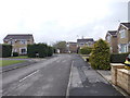
9
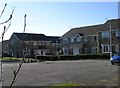
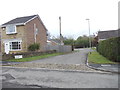
Housing Development - off Kirk Lane
These have been built on the site of the former Leafield Mills (James Ives & Co).
Image: © Betty Longbottom
Taken: 13 Feb 2008
0.08 miles
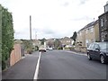
10
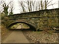
Whackhouse Lane bridge over the Yeadon cycleway
The cycleway runs for 1.3km from Engine Fields to Ghyll Royd and follows most of the length of the former Yeadon branch of the Midland Railway that closed in 1964.The original cutting must have been partly infilled, as there certainly isn't room for a standard gauge train to fit under the bridge at the present ground level.
Image: © Stephen Craven
Taken: 24 Jan 2021
0.08 miles