IMAGES TAKEN NEAR TO
Greenlea Close, LEEDS, LS19 7JL
Introduction
This page details the photographs taken nearby to Greenlea Close, LS19 7JL by members of the Geograph project.
The Geograph project started in 2005 with the aim of publishing, organising and preserving representative images for every square kilometre of Great Britain, Ireland and the Isle of Man.

There are currently over 7.5m images from over14,400 individuals and you can help contribute to the project by visiting https://www.geograph.org.uk
Image Map
Images are licensed for reuse under creativecommons.org/licenses/by-sa/2.0
Notes
- Clicking on the map will re-center to the selected point.
- The higher the marker number, the further away the image location is from the centre of the postcode.
Image Listing (76 Images Found)
Images are licensed for reuse under creativecommons.org/licenses/by-sa/2.0
Image
Details
Distance
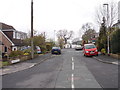
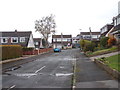
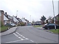
2
Greenlea Close, Yeadon
This photo will serve to represent typical housing on this estate.
Image: © Stephen Craven
Taken: 24 Jan 2021
0.05 miles
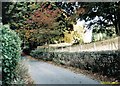
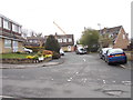
7
Driveway to Low Hall - Gill Lane
This photo was taken through the bars of a locked gate, the reflection of which can be seen on the driveway.
Image: © Betty Longbottom
Taken: 27 Mar 2012
0.12 miles
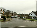
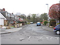
8
Greenlea Road - viewed from Woodlea Road
Image: © Betty Longbottom
Taken: 23 Apr 2012
0.13 miles