IMAGES TAKEN NEAR TO
South View Crescent, LEEDS, LS19 7JA
Introduction
This page details the photographs taken nearby to South View Crescent, LS19 7JA by members of the Geograph project.
The Geograph project started in 2005 with the aim of publishing, organising and preserving representative images for every square kilometre of Great Britain, Ireland and the Isle of Man.

There are currently over 7.5m images from over14,400 individuals and you can help contribute to the project by visiting https://www.geograph.org.uk
Image Map
Images are licensed for reuse under creativecommons.org/licenses/by-sa/2.0
Notes
- Clicking on the map will re-center to the selected point.
- The higher the marker number, the further away the image location is from the centre of the postcode.
Image Listing (81 Images Found)
Images are licensed for reuse under creativecommons.org/licenses/by-sa/2.0
Image
Details
Distance
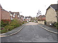
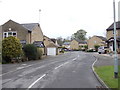
1
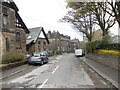
Milner's Road - viewed from South View
Image: © Betty Longbottom
Taken: 23 Apr 2012
0.06 miles
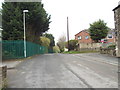
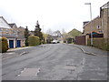
3
Milners Road, Guiseley
Classic "urban fringe": the road leads to a recycling facility on the site of the former Guiseley Brickworks and was crossed at this point (possibly on the level rather than by means of a bridge) by the Midland Railway's freight branch to Yeadon (now a cycleway).
Image: © Stephen Craven
Taken: 24 Jan 2021
0.07 miles
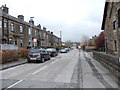
5
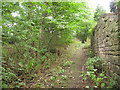
Footpath below Park View
The only reason I took a photo here is because I had mis-read a map and ended up on this footpath that became impassable due to vegetation a little further down the hill (behind the photographer in this view). The setted surface suggests it was once a well used route, probably for workers at the woollen mill in the valley bottom.
Image: © Stephen Craven
Taken: 14 Aug 2016
0.09 miles
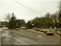
6
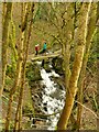
Footbridge over Nunroyd Beck
At the bottom of the photo the beck enters a long culvert under the embankment of the former the Midland Railway freight branch to Yeadon (now a cycleway).
Image: © Stephen Craven
Taken: 24 Jan 2021
0.09 miles
7
West View - looking towards Dibb Lane
Image: © Betty Longbottom
Taken: 23 Apr 2012
0.10 miles
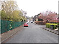
9
Crofters Lea - viewed from near Plowmans Walk
Image: © Betty Longbottom
Taken: 23 Apr 2012
0.11 miles