IMAGES TAKEN NEAR TO
Micklefield Court, LEEDS, LS19 6RY
Introduction
This page details the photographs taken nearby to Micklefield Court, LS19 6RY by members of the Geograph project.
The Geograph project started in 2005 with the aim of publishing, organising and preserving representative images for every square kilometre of Great Britain, Ireland and the Isle of Man.

There are currently over 7.5m images from over14,400 individuals and you can help contribute to the project by visiting https://www.geograph.org.uk
Image Map
Images are licensed for reuse under creativecommons.org/licenses/by-sa/2.0
Notes
- Clicking on the map will re-center to the selected point.
- The higher the marker number, the further away the image location is from the centre of the postcode.
Image Listing (175 Images Found)
Images are licensed for reuse under creativecommons.org/licenses/by-sa/2.0
Image
Details
Distance
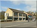
1

Rawdon Industrial Co-operative Society - Leeds Road, Rawdon
Image: © Betty Longbottom
Taken: 12 Feb 2008
0.02 miles
3
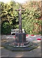
War Memorial - Garden of Remembrance - Leeds Road, Rawdon
Image: © Betty Longbottom
Taken: 12 Feb 2008
0.03 miles
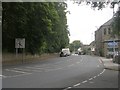
4
Micklefield Road - Micklefield Lane
Image: © Betty Longbottom
Taken: 31 Aug 2011
0.03 miles
5
Micklefield Lane - viewed from Micklefield Road
Image: © Betty Longbottom
Taken: 31 Aug 2011
0.03 miles
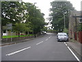
6
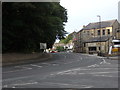
Micklefield Lane looking towards Rawdon Crossroads
Image: © Stephen Armstrong
Taken: 9 Aug 2018
0.03 miles
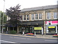
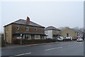
8
Shops on Leeds Road, Rawdon
The nearer block is somewhat newer than the further one.
Image: © Stephen Craven
Taken: 20 Mar 2021
0.03 miles

10
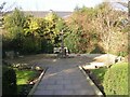
Garden of Remembrance - Leeds Road, Rawdon
Image: © Betty Longbottom
Taken: 12 Feb 2008
0.04 miles