IMAGES TAKEN NEAR TO
Markham Avenue, LEEDS, LS19 6QP
Introduction
This page details the photographs taken nearby to Markham Avenue, LS19 6QP by members of the Geograph project.
The Geograph project started in 2005 with the aim of publishing, organising and preserving representative images for every square kilometre of Great Britain, Ireland and the Isle of Man.

There are currently over 7.5m images from over14,400 individuals and you can help contribute to the project by visiting https://www.geograph.org.uk
Image Map (Loading...)


Getting Data...Please wait
Leaflet Map data © OpenStreetMap
Images are licensed for reuse under creativecommons.org/licenses/by-sa/2.0
Notes
- Clicking on the map will re-center to the selected point.
- The higher the marker number, the further away the image location is from the centre of the postcode.
Image Listing (100 Images Found)
Images are licensed for reuse under creativecommons.org/licenses/by-sa/2.0
Image
Details
Distance
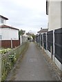
2
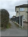
Footpath from Markham Crescent to Second Avenue
Unlike many such urban ginnels, this one is signed as a public footpath. It seems to correspond with a field boundary prior to development of the housing estate.
Image: © Stephen Craven
Taken: 28 Mar 2021
0.05 miles
4
Yeadon, Harrogate Road
According to the OS benchmark database, there was a benchmark cut into the works building at 86 Harrogate Road. This property has been demolished and a new build and perimeter wall are now in place. The benchmark has been destroyed.
Image: © Mel Towler
Taken: 16 Jan 2022
0.06 miles
6
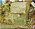
Old Milestone by the B6152, Harrogate Road, Rawdon Parish
Stone post (plate lost) by the B6152, in parish of Rawdon (BRADFORD District), Harrogate Road, Rawdon; 200m North East of Stone Trough Inn, by the road, on East side of road. Bradford Steps, erected by the Dudley Hill to Killinghall & Harrogate turnpike trust in the 19th century. Appears to have been moved between May 2018 and Aug 2020.
Inscription once read:- : (TO BRADFORD 6 MILE {hand} / {hand} TO HARROGATE 13 MILE) :
Milestone Society National ID: YW_BFHG06.
Image: © Christine Minto
Taken: 20 Oct 2007
0.07 miles
7
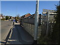
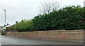
Lost milestone
On the B6152, old A658, Harrogate Road in Yeadon was a stepped milestone 6 miles from Bradford. [See https://www.geograph.org.uk/photo/6044094]
A new wall, fence and lamp post has now been erected and the old stone is no longer there.
Image: © Chris Minto
Taken: 4 Apr 2021
0.07 miles
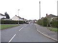
9
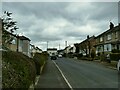
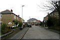
Second Avenue, Rawdon
An unimaginatively named road of semi-detached houses of probably 1940s/50 date.
Image: © Stephen Craven
Taken: 28 Mar 2021
0.07 miles
10
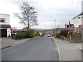
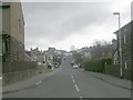
Markham Avenue - viewed from Markham Crescent
Image: © Betty Longbottom
Taken: 2 Apr 2012
0.08 miles