IMAGES TAKEN NEAR TO
Leeds Road, LEEDS, LS19 6NY
Introduction
This page details the photographs taken nearby to Leeds Road, LS19 6NY by members of the Geograph project.
The Geograph project started in 2005 with the aim of publishing, organising and preserving representative images for every square kilometre of Great Britain, Ireland and the Isle of Man.

There are currently over 7.5m images from over14,400 individuals and you can help contribute to the project by visiting https://www.geograph.org.uk
Image Map (Loading...)


Getting Data...Please wait
Leaflet Map data © OpenStreetMap
Images are licensed for reuse under creativecommons.org/licenses/by-sa/2.0
Notes
- Clicking on the map will re-center to the selected point.
- The higher the marker number, the further away the image location is from the centre of the postcode.
Image Listing (106 Images Found)
Images are licensed for reuse under creativecommons.org/licenses/by-sa/2.0
Image
Details
Distance
5
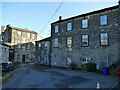
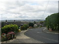
Courtyard at Low Green, Rawdon
Low Green is a small area of mainly older stone buildings just off the A65. None of them are nationally listed but Low Green has its own conservation area, and the appraisal document available online describes it as "a historic settlement with evidence of occupation from the 17th century to the present day". The three storey buildings such as the one here are 18th or 19th century weaver's houses.
Image: © Stephen Craven
Taken: 15 Nov 2020
0.10 miles
6

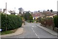
Low Green, Rawdon
A small area of mainly older stone buildings just off the A65. None of them are nationally listed but Low Green has its own conservation area, and the appraisal document available online describes it as "a historic settlement with evidence of occupation from the 17th century to the present day".
Image: © Stephen Craven
Taken: 15 Nov 2020
0.10 miles
7

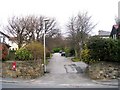
Stop sign at the bottom of Well Lane
The octagonal Stop sign is relatively uncommon compared with the triangular Give Way sign. It is probably used here as the lane meets the busy A65 with poor sightlines.
Image: © Stephen Craven
Taken: 15 Nov 2020
0.11 miles
8
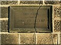
Former Friends' School, Low Green, Rawdon - datestone
The date of 1898 refers to when the school building was extended, rather than its original construction. See Image for context.
Image: © Stephen Craven
Taken: 15 Nov 2020
0.11 miles
9
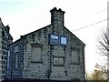
Former Friends' School, Low Green, Rawdon - detail
The former school is now occupied by a signage business. Some of the original windows have been blocked up. See Image for context.
Image: © Stephen Craven
Taken: 15 Nov 2020
0.11 miles