IMAGES TAKEN NEAR TO
New York Lane, LEEDS, LS19 6JJ
Introduction
This page details the photographs taken nearby to New York Lane, LS19 6JJ by members of the Geograph project.
The Geograph project started in 2005 with the aim of publishing, organising and preserving representative images for every square kilometre of Great Britain, Ireland and the Isle of Man.

There are currently over 7.5m images from over14,400 individuals and you can help contribute to the project by visiting https://www.geograph.org.uk
Image Map (Loading...)


Getting Data...Please wait
Leaflet Map data © OpenStreetMap
Images are licensed for reuse under creativecommons.org/licenses/by-sa/2.0
Notes
- Clicking on the map will re-center to the selected point.
- The higher the marker number, the further away the image location is from the centre of the postcode.
Image Listing (84 Images Found)
Images are licensed for reuse under creativecommons.org/licenses/by-sa/2.0
Image
Details
Distance
1
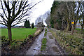
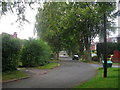
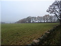
New York Lane, Horsforth
Part of the Leeds Country Way long distance footpath.
Image: © John Sparshatt
Taken: 2 Jan 2013
0.04 miles
8
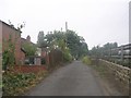
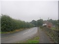
A65 at Knott Lane, Rawdon
There is an OS Cut Benchmark on the dry stone wall at the left side of the picture.
Image: © Stephen Armstrong
Taken: 5 Mar 2019
0.07 miles
10
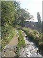
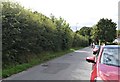
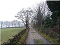
New York Lane - viewed from Footpath
Image: © Betty Longbottom
Taken: 19 Sep 2011
0.08 miles