IMAGES TAKEN NEAR TO
Larkfield Road, LEEDS, LS19 6EQ
Introduction
This page details the photographs taken nearby to Larkfield Road, LS19 6EQ by members of the Geograph project.
The Geograph project started in 2005 with the aim of publishing, organising and preserving representative images for every square kilometre of Great Britain, Ireland and the Isle of Man.

There are currently over 7.5m images from over14,400 individuals and you can help contribute to the project by visiting https://www.geograph.org.uk
Image Map (Loading...)


Getting Data...Please wait
Leaflet Map data © OpenStreetMap
Images are licensed for reuse under creativecommons.org/licenses/by-sa/2.0
Notes
- Clicking on the map will re-center to the selected point.
- The higher the marker number, the further away the image location is from the centre of the postcode.
Image Listing (116 Images Found)
Images are licensed for reuse under creativecommons.org/licenses/by-sa/2.0
Image
Details
Distance
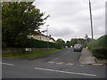
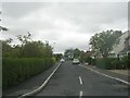
2
Larkfield Road - viewed from Batter Lane
Image: © Betty Longbottom
Taken: 19 Sep 2011
0.04 miles
5

Larkfield Dam
This former mill dam is now owned by a model boat club.
Image: © John Illingworth
Taken: 12 Jul 2006
0.05 miles
9
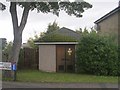
Electricity Substation No 4223 - Mount Vernon Road
Image: © Betty Longbottom
Taken: 19 Sep 2011
0.09 miles
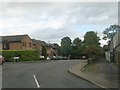
10
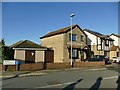
Mount Vernon Road, Rawdon
A substation, and some of the houses built on the site on the former Larkfield Mill.
Image: © Stephen Craven
Taken: 15 Nov 2020
0.09 miles