IMAGES TAKEN NEAR TO
Fairfax View, LEEDS, LS18 5SZ
Introduction
This page details the photographs taken nearby to Fairfax View, LS18 5SZ by members of the Geograph project.
The Geograph project started in 2005 with the aim of publishing, organising and preserving representative images for every square kilometre of Great Britain, Ireland and the Isle of Man.

There are currently over 7.5m images from over14,400 individuals and you can help contribute to the project by visiting https://www.geograph.org.uk
Image Map
Images are licensed for reuse under creativecommons.org/licenses/by-sa/2.0
Notes
- Clicking on the map will re-center to the selected point.
- The higher the marker number, the further away the image location is from the centre of the postcode.
Image Listing (11 Images Found)
Images are licensed for reuse under creativecommons.org/licenses/by-sa/2.0
Image
Details
Distance
1
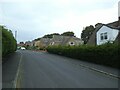
Argyll Close, off Scotland Way, Horsforth
A dead-end street.
Image: © Stephen Craven
Taken: 22 Sep 2020
0.08 miles
2
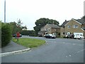
Junction of Argyll Close and Scotland Way, Horsforth
With a postbox on the corner.
Image: © Stephen Craven
Taken: 22 Sep 2020
0.11 miles
3
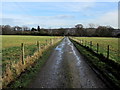
Access Lane to Beech House
Access from Scotland Lane, Horsforth - and adopted by a public footpath.
Image: © Chris Heaton
Taken: 27 Jan 2014
0.12 miles
5
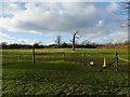
Field with dead tree off Scotland Lane
The field looks to be used as a horse paddock, and the tree is a feature of it.
Image: © Stephen Craven
Taken: 9 Dec 2018
0.19 miles
6
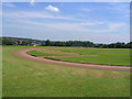
Sportsground at Leeds University
The Sports ground Adjacent to the University of Leeds
Image: © Mick Melvin
Taken: 22 Jun 2005
0.23 miles
7
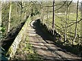
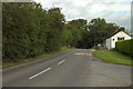
The lane to Owlet Farm
Looking down from Scotland Lane
Image: © Rich Tea
Taken: 3 Feb 2007
0.23 miles
8
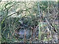
Scotland Beck
Looking down from Scotland Lane as the Beck flows into the culvert under the road.
Image: © Rich Tea
Taken: 3 Feb 2007
0.23 miles
9
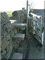
Stone stile and broken gate
On the private road / public footpath from Scotland Lane, past the stable and houses at Image], leading to the reservoir Image The post by the stile has a "Public Footpath" sign at the top.
Image: © Rich Tea
Taken: 3 Feb 2007
0.23 miles
10
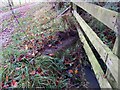
Horsforth, track near Scotland hamlet
According to the OS benchmark database there is a rivet benchmark cut into the culvert on the east side of the path. Nothing was found.
Image: © Mel Towler
Taken: 22 Nov 2022
0.24 miles