IMAGES TAKEN NEAR TO
Salisbury View, LEEDS, LS18 5QP
Introduction
This page details the photographs taken nearby to Salisbury View, LS18 5QP by members of the Geograph project.
The Geograph project started in 2005 with the aim of publishing, organising and preserving representative images for every square kilometre of Great Britain, Ireland and the Isle of Man.

There are currently over 7.5m images from over14,400 individuals and you can help contribute to the project by visiting https://www.geograph.org.uk
Image Map (Loading...)


Getting Data...Please wait
Leaflet Map data © OpenStreetMap
Images are licensed for reuse under creativecommons.org/licenses/by-sa/2.0
Notes
- Clicking on the map will re-center to the selected point.
- The higher the marker number, the further away the image location is from the centre of the postcode.
Image Listing (95 Images Found)
Images are licensed for reuse under creativecommons.org/licenses/by-sa/2.0
Image
Details
Distance
1
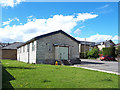
St James's parish centre, Low Lane, Horsforth
The building was principally used as a scout hut some years ago Image but the scouting logo has gone and it is known as the parish centre.
Image: © Stephen Craven
Taken: 27 Apr 2020
0.05 miles
2
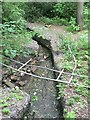
Concrete tank (1), Horsforth
This is one of a group of concrete and brick tanks in the wood between Oil Mill Beck and the railway line near Low Mill. They are now surrounded and hidden by trees, which have grown around them. They can be seen together in an aerial photo taken in the 1930's when they were probably in use by Low Mill, on page 18 of "Woodside and its Industries" a Horsforth History Guide published by Horsforth Village Publications, ISBN 0947904026
See also Image]
Image: © Rich Tea
Taken: 26 May 2008
0.05 miles
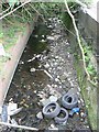
3
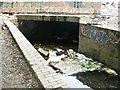
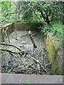
Oil Mill Beck at Low Mill Horsforth (1)
Oil Mill Beck flows under Low Mill, and is seen here at the north side entering the conduit. The Mill has recently been demolished but the concrete floor remains over the beck.
see Image] and Image]
Image: © Rich Tea
Taken: 26 May 2008
0.05 miles
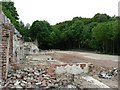
4
The remains of Low Mill, Horsforth (2)
Another view of the location of Low Mill, recently demolished.
See Image]
Image: © Rich Tea
Taken: 26 May 2008
0.05 miles
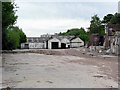
5
The remains of Low Mill, Horsforth (1)
Low Mill dated back to the 18th century, and made paper until the 1870's when it became Horsforth Steel Works, making among other things the steel needles for wind-up gramophones. In 1905 it became a textile dyeworks.
The mill has been demolished within the past few months. See Image] and Image]
See "Woodside and its Industries" a Horsforth History Guide published by Horsforth Village Publications, ISBN 0947904026
Image: © Rich Tea
Taken: 26 May 2008
0.05 miles
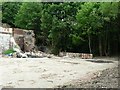
6
The remains of Low Mill, Horsforth (3)
The wall remains at the west side of the site, and the concrete floor, but not much else.
See Image]
Image: © Rich Tea
Taken: 26 May 2008
0.05 miles
7

Horsforth, 206 Low Lane
There is a benchmark cut into the gable end of the brick built property. It is just beyond the short stretch of garden wall.
Image: © Mel Towler
Taken: 28 Dec 2021
0.07 miles
8

Horsforth, 206 Low Lane
The benchmark is cut into the gable end of the property.
Image: © Mel Towler
Taken: 28 Dec 2021
0.07 miles
9
Oil Mill Beck at Low Mill Horsforth (2)
This is where Oil Mill Beck emerges from underneath Low Mill, which was recently demolished.
See Image] and Image]
Image: © Rich Tea
Taken: 26 May 2008
0.07 miles