IMAGES TAKEN NEAR TO
Church Road, LEEDS, LS18 5LQ
Introduction
This page details the photographs taken nearby to Church Road, LS18 5LQ by members of the Geograph project.
The Geograph project started in 2005 with the aim of publishing, organising and preserving representative images for every square kilometre of Great Britain, Ireland and the Isle of Man.

There are currently over 7.5m images from over14,400 individuals and you can help contribute to the project by visiting https://www.geograph.org.uk
Image Map
Images are licensed for reuse under creativecommons.org/licenses/by-sa/2.0
Notes
- Clicking on the map will re-center to the selected point.
- The higher the marker number, the further away the image location is from the centre of the postcode.
Image Listing (334 Images Found)
Images are licensed for reuse under creativecommons.org/licenses/by-sa/2.0
Image
Details
Distance
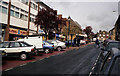
1
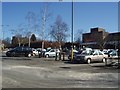
Morrisons Car Park, Horsforth
Looking north across the car park off Church Road
Image: © Rich Tea
Taken: 5 Mar 2006
0.01 miles
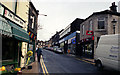
2
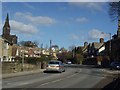
Church Road, Horsforth
Looking north towards the junction of Hall Park Avenue, and St Margarets Church.
Image: © Rich Tea
Taken: 5 Mar 2006
0.01 miles
3
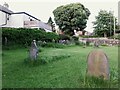
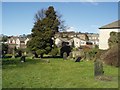
Top end of St Margaret's burial ground
This is the detached burial ground of St Margaret's church, Horsforth (there are no burials around the 19th century church itself). It is now managed by a community group, Horsforth in Bloom although it is still used for interment of cremated remains.
Image: © Stephen Craven
Taken: 11 Jun 2021
0.01 miles
4
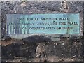
Plaque on a burial ground wall
An unusual sign: the other side of the wall is the detached burial ground of St Margaret's church, Horsforth Image
Image: © Stephen Craven
Taken: 11 Jun 2021
0.02 miles
5
Graveyard, Church Road, Horsforth
This small graveyard is on the west side of Church Road, between Hall Lane and Hall Park Avenue.
Image: © Rich Tea
Taken: 5 Mar 2006
0.02 miles
6
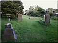
Bottom end of St Margaret's burial ground
This is the detached burial ground of St Margaret's church, Horsforth (there are no burials around the 19th century church itself). It is now managed by a community group, Horsforth in Bloom although it is still used for interment of cremated remains.
Image: © Stephen Craven
Taken: 11 Jun 2021
0.02 miles
7
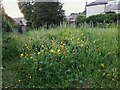
Buttercups in a burial ground
This is the detached burial ground of St Margaret's church, Horsforth (there are no burials around the 19th century church itself, the spire of which can be seen in the background). It is now managed by a community group, Horsforth in Bloom although it is still used for interment of cremated remains.
Image: © Stephen Craven
Taken: 11 Jun 2021
0.02 miles
8
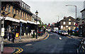
Town Street, Horsforth
Looking north-east
Image: © Dr Neil Clifton
Taken: 15 Apr 1999
0.02 miles
9
Town Street, Horsforth
Looking north-east
Image: © Dr Neil Clifton
Taken: 15 Apr 1999
0.02 miles
10
Town Street, Horsforth
Looking north-east
Image: © Dr Neil Clifton
Taken: 15 Apr 1999
0.03 miles