IMAGES TAKEN NEAR TO
Scotland Lane, LEEDS, LS18 5HS
Introduction
This page details the photographs taken nearby to Scotland Lane, LS18 5HS by members of the Geograph project.
The Geograph project started in 2005 with the aim of publishing, organising and preserving representative images for every square kilometre of Great Britain, Ireland and the Isle of Man.

There are currently over 7.5m images from over14,400 individuals and you can help contribute to the project by visiting https://www.geograph.org.uk
Image Map
Images are licensed for reuse under creativecommons.org/licenses/by-sa/2.0
Notes
- Clicking on the map will re-center to the selected point.
- The higher the marker number, the further away the image location is from the centre of the postcode.
Image Listing (9 Images Found)
Images are licensed for reuse under creativecommons.org/licenses/by-sa/2.0
Image
Details
Distance
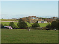
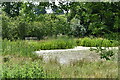
4
Oaks Farm, Horsforth
Viewed from Scotland Lane.
Image: © Stephen Armstrong
Taken: 7 Apr 2011
0.19 miles
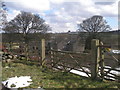
6
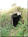
Potato Storage
This underground cool house was used for potato storage. According to a local historian, in the more remote past it may have been an ice house for a farm house that is no longer here.
Image: © vad falcone
Taken: 6 Oct 2007
0.19 miles

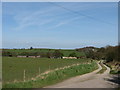
9
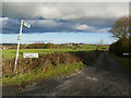
Start of the bridleway to Cookridge
The track also gives access to Dean Grange Farm.
Image: © Stephen Craven
Taken: 9 Dec 2018
0.25 miles