IMAGES TAKEN NEAR TO
Springfield Rise, LEEDS, LS18 5DS
Introduction
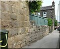
This page details the photographs taken nearby to Springfield Rise, LS18 5DS by members of the Geograph project.
The Geograph project started in 2005 with the aim of publishing, organising and preserving representative images for every square kilometre of Great Britain, Ireland and the Isle of Man.

There are currently over 7.5m images from over14,400 individuals and you can help contribute to the project by visiting https://www.geograph.org.uk
Image Map
Images are licensed for reuse under creativecommons.org/licenses/by-sa/2.0
Notes
- Clicking on the map will re-center to the selected point.
- The higher the marker number, the further away the image location is from the centre of the postcode.
Image Listing (104 Images Found)
Images are licensed for reuse under creativecommons.org/licenses/by-sa/2.0
Image
Details
Distance
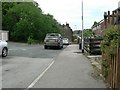
1
Springfield Gardens, Horsforth
Looking east towards Low Lane at the end of the road.
Image: © Rich Tea
Taken: 1 Mar 2006
0.03 miles
2
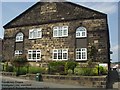
Providence Chapel, Broadgate Lane, Horsforth
Now converted to apartments, it is on the north side of Broadgate Lane, between Low Lane and Broadgate Avenue
Image: © Rich Tea
Taken: Unknown
0.05 miles
3
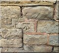
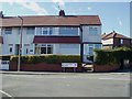
Horsforth, 1 Mount Pleasant
The benchmark is cut into the south facing gable end of the property.
Image: © Mel Towler
Taken: 3 Sep 2022
0.05 miles
4
Horsforth, 1 Mount Pleasant
There is a benchmark cut into the south facing gable end of the property. The cutmark is where the corner of the house adjoins the boundary wall.
Image: © Mel Towler
Taken: 3 Sep 2022
0.05 miles
5
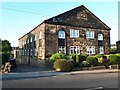
Former Providence chapel, Broadgate Lane
A former Methodist chapel dating from 1864. See also Image
Image: © Stephen Craven
Taken: 8 Sep 2021
0.06 miles
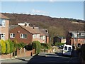
6
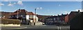
Springfield Mount & Springfield Gardens, Horsforth
A view down Springfield Mount, looking east, from just above Springfield Gardens on the left.
Image: © Rich Tea
Taken: 1 Mar 2006
0.07 miles
7
Springfield Rise, Horsforth
From Springfield Mount
Image: © Rich Tea
Taken: 1 Mar 2006
0.07 miles
8
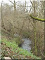
Oil Mill Beck, Horsforth
From the car park of Don Controls, Low Lane, which is between the junctions with Broadgate Lane and Springfield Mount.
Image: © Rich Tea
Taken: 2 Jan 2006
0.08 miles
9
Ginnel, Springfield Gardens, Horsforth
The ginnel (back alley) between Springfield Gardens on the right and Springfield Mount on the left.
Image: © Rich Tea
Taken: 25 Jun 2006
0.08 miles