IMAGES TAKEN NEAR TO
Outwood Chase, LEEDS, LS18 4UR
Introduction
This page details the photographs taken nearby to Outwood Chase, LS18 4UR by members of the Geograph project.
The Geograph project started in 2005 with the aim of publishing, organising and preserving representative images for every square kilometre of Great Britain, Ireland and the Isle of Man.

There are currently over 7.5m images from over14,400 individuals and you can help contribute to the project by visiting https://www.geograph.org.uk
Image Map
Images are licensed for reuse under creativecommons.org/licenses/by-sa/2.0
Notes
- Clicking on the map will re-center to the selected point.
- The higher the marker number, the further away the image location is from the centre of the postcode.
Image Listing (191 Images Found)
Images are licensed for reuse under creativecommons.org/licenses/by-sa/2.0
Image
Details
Distance
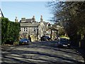
1
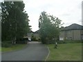
Outwood Chase - viewed from Woodside Park Avenue
Image: © Betty Longbottom
Taken: 6 Jun 2011
0.01 miles
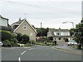
2
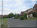
Woodside Park Avenue - looking towards Woodside Park Drive
Image: © Betty Longbottom
Taken: 6 Jun 2011
0.05 miles
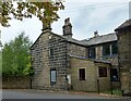
3
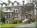
Summerfield House, Outwood Lane, Horsforth, Leeds
One of the large late 19th century and early 20th century houses along Outwood Lane. Several of these houses were built for the families of the four Whitaker brothers, who ran local quarries and were stone merchants and building contractors
Image: © Rich Tea
Taken: 20 Feb 2006
0.05 miles
4
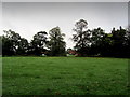
Open Ground North of Outwood Lane
Surrounded by housing, this stretch of open ground is a good place for recreation and dog walking - yet it seems always under threat from bricks and mortar
Image: © Chris Heaton
Taken: 12 Oct 2013
0.05 miles
5
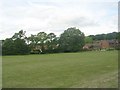
Recreation Ground - Woodside Park Avenue
Image: © Betty Longbottom
Taken: 6 Jun 2011
0.07 miles
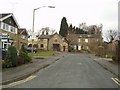
6
Knoll Wood Park, Horsforth
Looking from Outwood Lane.
Knoll Wood Park takes its name from the Elf Knoll, the hill to the left, which probably had a stone circle in the past. The earliest mention of Elf Knoll is in a Kirkstall Abbey deed of 1451 " le Elff Knolles on the east of the vill of Horsforth"
Image: © Rich Tea
Taken: 26 May 2008
0.07 miles
7
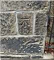
Horsforth, Outwood Lane
The benchmark is cut into the south-east facing wall of Woodville. This is the gable end which faces the road.
Image: © Mel Towler
Taken: 3 Sep 2022
0.07 miles
8
Horsforth, Outwood Lane
There is a benchmark cut into the south-east facing wall of Woodville. This is the gable end which faces the road.
Image: © Mel Towler
Taken: 3 Sep 2022
0.07 miles
9
Outwood Lane, Horsforth
Looking north-east by Outwood House.
Image: © Rich Tea
Taken: 1 Mar 2006
0.07 miles
10
Woodside Place, Horsforth, Leeds
A short road showing a typical Horsforth mixture of old and new buildings.
Image: © Rich Tea
Taken: 20 Feb 2006
0.07 miles