IMAGES TAKEN NEAR TO
Outwood Lane, LEEDS, LS18 4UP
Introduction
This page details the photographs taken nearby to Outwood Lane, LS18 4UP by members of the Geograph project.
The Geograph project started in 2005 with the aim of publishing, organising and preserving representative images for every square kilometre of Great Britain, Ireland and the Isle of Man.

There are currently over 7.5m images from over14,400 individuals and you can help contribute to the project by visiting https://www.geograph.org.uk
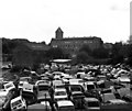
Image Map
Images are licensed for reuse under creativecommons.org/licenses/by-sa/2.0
Notes
- Clicking on the map will re-center to the selected point.
- The higher the marker number, the further away the image location is from the centre of the postcode.
Image Listing (159 Images Found)
Images are licensed for reuse under creativecommons.org/licenses/by-sa/2.0
Image
Details
Distance
1
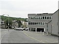
Bridge House, Horsforth
Offices occupied by BUPA, at the corner of Outwood Lane (on my left) and Low Lane (beyond the building)
Image: © Rich Tea
Taken: 26 May 2008
0.01 miles
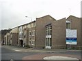
2

Industrial premises, Outwood Lane
The building is on the site of a former tannery but I don't know which business occupies it: the truck in the foreground has the name of a company based in Armley rather than here.
Image: © Stephen Craven
Taken: 2 Jun 2020
0.02 miles
3
Outwood Lane - viewed from Knoll Wood Park
Image: © Betty Longbottom
Taken: 6 Jun 2011
0.03 miles
4
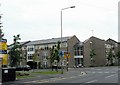
Millbeck Park, Horsforth, Leeds
This is a new development of houses and apartments on an old industrial site, Corn Mill Fold, of which one very old building remains, out of picture to the left. In the 1850's it was the centre of the Whitaker's business of quarrying and stone merchants, but by the time I first knew the area in the early 1980's there was a tyre and exhaust centre (Charlie Brown's) where the road junction is now, and a large scrapyard behind it.
Image: © Rich Tea
Taken: 20 Feb 2006
0.03 miles
5
Corn Mill Fold, Horsforth
An ancient, listed structure, in the midst of the Millbeck Park development.
See the same building 18 years earlier Image]
Image: © Rich Tea
Taken: 1 Mar 2006
0.03 miles
6
Horsforth Mill and old corn mill
In this view, the old corn mill and the much more modern Horsforth Mill (woollen) are seen across a sea of scrap cars.
Image: © Dr Neil Clifton
Taken: 30 May 1988
0.03 miles
7
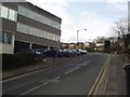
Cornmill View, Horsforth
A new development on the site of a former tyre fitters (Charlie Browns, where the junction is now) and scrapyard (further from the camera). Compare with Image], taken in 1992, from Charlie Browns. The top of the tower of Horsforth Mill is just visible over the modern roofs in the centre of the picture.
Image: © Rich Tea
Taken: 26 May 2008
0.03 miles
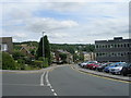
8
Outwood Lane, Horsforth, Leeds
The north-eastern end of Outwood Lane, looking south-west from its junction with Low Lane.
Image: © Rich Tea
Taken: 20 Feb 2006
0.03 miles
9
Bollards on Tan House Hill
Preventing through traffic on this narrow street. The tannery after which it was named was at the other end of the street and is no longer extant.
Image: © Stephen Craven
Taken: 2 Jun 2020
0.04 miles
10
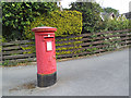
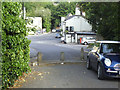
Post box, Outwood Lane
A standard EIIR pillar box.
Image: © Stephen Craven
Taken: 2 Jun 2020
0.04 miles