IMAGES TAKEN NEAR TO
Manor Mews, LEEDS, LS18 4GU
Introduction
This page details the photographs taken nearby to Manor Mews, LS18 4GU by members of the Geograph project.
The Geograph project started in 2005 with the aim of publishing, organising and preserving representative images for every square kilometre of Great Britain, Ireland and the Isle of Man.

There are currently over 7.5m images from over14,400 individuals and you can help contribute to the project by visiting https://www.geograph.org.uk
Image Map
Images are licensed for reuse under creativecommons.org/licenses/by-sa/2.0
Notes
- Clicking on the map will re-center to the selected point.
- The higher the marker number, the further away the image location is from the centre of the postcode.
Image Listing (271 Images Found)
Images are licensed for reuse under creativecommons.org/licenses/by-sa/2.0
Image
Details
Distance
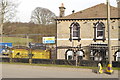
1
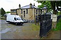
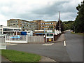
Stanhope Hotel, Calverley Lane, Leeds
Image: © Mark Stevenson
Taken: 7 May 2014
0.01 miles
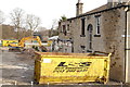
2
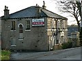
Demolition of the former Oliver's Paris restaurant (1)
Image: © Rich Tea
Taken: 13 Mar 2016
0.01 miles
3
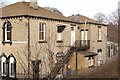
Olivers Paris Restaurant and Bar, Calverley Lane
The restaurant closed quite unexpectedly in September 2007, "Due to difficult trading conditions". The business went into liquidation and the building is To Let.
Olivers Paris Restaurant was originally on Town Street in Horsforth, and moved to this building a few years ago.
Image: © Rich Tea
Taken: 23 Dec 2007
0.02 miles
4
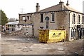
Demolition of the former Oliver's Paris restaurant (4)
Image: © Rich Tea
Taken: 13 Mar 2016
0.02 miles
5
Demolition of the former Oliver's Paris restaurant (2)
Image: © Rich Tea
Taken: 13 Mar 2016
0.02 miles
6
Demolition of the former Oliver's Paris restaurant (3)
Image: © Rich Tea
Taken: 13 Mar 2016
0.02 miles
7
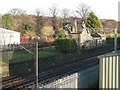
Railway from Calverley Lane bridge
With the back of Olivers Restaurant on the left, an old railway building right of centre and new industrial building on the left.
Image: © Rich Tea
Taken: 23 Dec 2007
0.02 miles
8
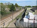
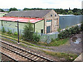
Railway east of Calverley Lane
The building to the right, at least the older stone part of it, was part of the former Calverley and Rodley station which was not particularly close to either village and closed in 1965. It is seen more fully in Image where it is described as a locomotive shed, although I think more likely a goods warehouse. The platforms were the other side of the bridge.
Image: © Stephen Craven
Taken: 8 May 2016
0.03 miles
9
Clariant chemical works
In Calverley Bar Lane near Horsforth.
Image: © David Spencer
Taken: 27 Aug 2005
0.03 miles
10
Old shed, new shed
The locomotive shed at the former site of Calverley station has been swallowed by the stupefyingly crass addition of huge tin sheds on three sides.
Image: © David Spencer
Taken: 27 Aug 2005
0.03 miles