IMAGES TAKEN NEAR TO
Bankfield, LEEDS, LS17 9AP
Introduction
This page details the photographs taken nearby to Bankfield, LS17 9AP by members of the Geograph project.
The Geograph project started in 2005 with the aim of publishing, organising and preserving representative images for every square kilometre of Great Britain, Ireland and the Isle of Man.

There are currently over 7.5m images from over14,400 individuals and you can help contribute to the project by visiting https://www.geograph.org.uk
Image Map
Images are licensed for reuse under creativecommons.org/licenses/by-sa/2.0
Notes
- Clicking on the map will re-center to the selected point.
- The higher the marker number, the further away the image location is from the centre of the postcode.
Image Listing (32 Images Found)
Images are licensed for reuse under creativecommons.org/licenses/by-sa/2.0
Image
Details
Distance
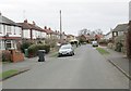
1
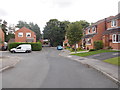
Bankfield - viewed from Woodacre Green
Image: © Betty Longbottom
Taken: 3 Aug 2015
0.01 miles
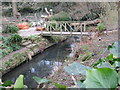
4
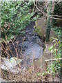
Keswick Lane bridge
The low parapets and overhanging trees make this road bridge over Keswick Beck quite unnoticeable.
Image: © Stephen Craven
Taken: 10 Jun 2023
0.06 miles
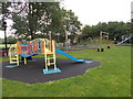
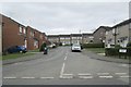
8
Bardsey Cricket Ground - off Keswick Lane
Image: © Betty Longbottom
Taken: 21 Mar 2015
0.09 miles
9
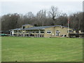
Bardsey Cricket Pavilion - off Keswick Lane
Image: © Betty Longbottom
Taken: 21 Mar 2015
0.10 miles
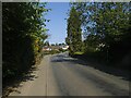
10
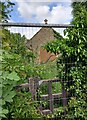
East Keswick, Catholic Church of the Blessed Sacrament
A former place of worship which is now boarded up and totally inaccessible due to the restrictive fencing around the site and a padlock. There should be a benchmark on the east face of the building.
Image: © Mel Towler
Taken: 20 Jun 2021
0.11 miles