IMAGES TAKEN NEAR TO
Longwood Crescent, LEEDS, LS17 8SR
Introduction
This page details the photographs taken nearby to Longwood Crescent, LS17 8SR by members of the Geograph project.
The Geograph project started in 2005 with the aim of publishing, organising and preserving representative images for every square kilometre of Great Britain, Ireland and the Isle of Man.

There are currently over 7.5m images from over14,400 individuals and you can help contribute to the project by visiting https://www.geograph.org.uk
Image Map
Images are licensed for reuse under creativecommons.org/licenses/by-sa/2.0
Notes
- Clicking on the map will re-center to the selected point.
- The higher the marker number, the further away the image location is from the centre of the postcode.
Image Listing (62 Images Found)
Images are licensed for reuse under creativecommons.org/licenses/by-sa/2.0
Image
Details
Distance
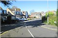
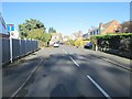
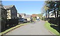
2
Longwood Close - viewed from Longwood Crescent
Image: © Betty Longbottom
Taken: 4 Nov 2013
0.03 miles
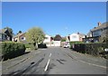
3
Longwood close - viewed from Longwood Crescent
Image: © Betty Longbottom
Taken: 4 Nov 2013
0.04 miles
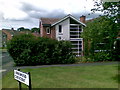
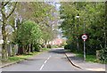
5
Silverdale Avenue - Plantation Gardens
Image: © Betty Longbottom
Taken: 4 Nov 2013
0.07 miles
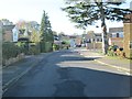
8
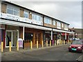
Shops at Wike Ridge Lane, Slaid Hill, Leeds
On the west side of the road near the junction with Shadwell Lane.
Image: © Rich Tea
Taken: 25 Jan 2006
0.09 miles
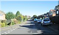
10

Middlethorne Rise - Middlethorne Close
Image: © Betty Longbottom
Taken: 4 Nov 2013
0.10 miles