IMAGES TAKEN NEAR TO
Red Hall Lane, LEEDS, LS17 8NB
Introduction
This page details the photographs taken nearby to Red Hall Lane, LS17 8NB by members of the Geograph project.
The Geograph project started in 2005 with the aim of publishing, organising and preserving representative images for every square kilometre of Great Britain, Ireland and the Isle of Man.

There are currently over 7.5m images from over14,400 individuals and you can help contribute to the project by visiting https://www.geograph.org.uk
Image Map
Images are licensed for reuse under creativecommons.org/licenses/by-sa/2.0
Notes
- Clicking on the map will re-center to the selected point.
- The higher the marker number, the further away the image location is from the centre of the postcode.
Image Listing (25 Images Found)
Images are licensed for reuse under creativecommons.org/licenses/by-sa/2.0
Image
Details
Distance
1
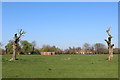
Looking West towards Redhall House
A large green space beside the A58, looking as if it is used recreational purposes - running up towards Redhall House
Image: © Chris Heaton
Taken: 9 Apr 2017
0.01 miles
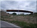
2
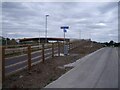
Slope to the footbridge over the ELOR at Red Hall
Signed to Shadwell, Collingham and Wetherby (via the A58).
Image: © Stephen Craven
Taken: 26 Aug 2022
0.08 miles
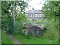
3
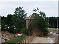
The pigeon house at Red Hall
An 18th century dovecot or pigeon house, restored in 1975 and listed grade II (list entry 1256164). Until the construction of the ELOR and its cycle lane, this would not have been visible from a public place.
Image: © Stephen Craven
Taken: 26 Aug 2022
0.08 miles
4
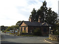
Red Hall lodge
Red Hall Image was the HQ of Leeds City Council's gardening department until the Arium Image opened in 2017. The lodge, at least, is currently disused.
Image: © Stephen Craven
Taken: 14 Sep 2019
0.10 miles
5
Footbridge over the ELOR at Red Hall
Like other foot and cycle crossings of the orbital road, this one is a single span girder bridge, probably of 'cor-ten' steel.
Image: © Stephen Craven
Taken: 26 Aug 2022
0.11 miles
6
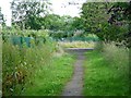
Well-used path on disused track
Leading south from Whinmoor Lane towards Redhall House and Red Hall Nurseries. The security fencing on the left protects a mapped but anonymous 'depot'.
Image: © Christine Johnstone
Taken: 18 Jul 2012
0.12 miles
7
They shall not pass!
Blocked gate at the northern end of the track from Redhall House to Whinmoor Lane.
Image: © Christine Johnstone
Taken: 18 Jul 2012
0.14 miles
8
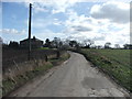
Whinmoor Lane.
S of Shadwell, looking SE. The house is called Barnaby Cottage.
Image: © Steve Partridge
Taken: 17 Feb 2006
0.15 miles
9
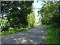
Whinmoor Lane
Heading east towards the A58.
Image: © Christine Johnstone
Taken: 18 Jul 2012
0.15 miles
10
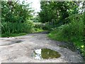
Lay-by and turning area, Whinmoor Lane
The lane curves round a 90 degree bend, but the boundary forms two sides of a square, leaving this patch of land between.
Image: © Christine Johnstone
Taken: 18 Jul 2012
0.15 miles