IMAGES TAKEN NEAR TO
Crescent View, LEEDS, LS17 7QF
Introduction
This page details the photographs taken nearby to Crescent View, LS17 7QF by members of the Geograph project.
The Geograph project started in 2005 with the aim of publishing, organising and preserving representative images for every square kilometre of Great Britain, Ireland and the Isle of Man.

There are currently over 7.5m images from over14,400 individuals and you can help contribute to the project by visiting https://www.geograph.org.uk
Image Map (Loading...)


Getting Data...Please wait
Leaflet Map data © OpenStreetMap
Images are licensed for reuse under creativecommons.org/licenses/by-sa/2.0
Notes
- Clicking on the map will re-center to the selected point.
- The higher the marker number, the further away the image location is from the centre of the postcode.
Image Listing (47 Images Found)
Images are licensed for reuse under creativecommons.org/licenses/by-sa/2.0
Image
Details
Distance
2
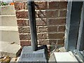
Alwoodley, 764 King Lane
The benchmark is cut into the south facing wall of the property. It is located to the right of the black drainpipe and to the left of the security gates.
Image: © Mel Towler
Taken: 14 Jul 2022
0.05 miles
3
Alwoodley, 764 King Lane
There is a benchmark cut into the south facing wall of the property. It is located to the right of a black drainpipe and to the left of the security gates.
Image: © Mel Towler
Taken: 14 Jul 2022
0.06 miles
4
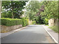
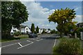
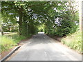
Houses on Alwoodley Lane
Looking west along Alwoodley Lane.
Image: © DS Pugh
Taken: 5 Jun 2021
0.06 miles
5
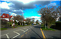
View east along Alwoodley Lane
Looking along Alwoodley Lane on the northern edge of Leeds.
Image: © DS Pugh
Taken: 5 Jun 2021
0.07 miles
6
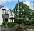
Alwoodley Lane near to the junction with King Lane, Alwoodley
Image: © Humphrey Bolton
Taken: 12 Mar 2022
0.07 miles
7
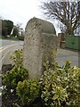
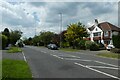
Old guidestone
This dated guidestone/milestone is set up in Alwoodley at the corner of King Lane and Alwoodley Lane. The little garden surrounding it has been tended by locals for over 40 years. The front is inscribed JB/1764/To Leedes/4M hand pointing right/To Otley/5M/hand pointing left. The right side has 1921/GD (or perhaps GB). The hands are upside down with the thumb pointing down. (Try that). The GD or GB may be for Geoffrey Bingley a photographer in the 1920s.
Image: © Chris Minto
Taken: 19 Mar 2023
0.07 miles
8
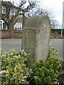
Old guidestone
This shows the inscription on the left face of the Alwoodley guidestone/milestone. To York/20M/hand pointing left/To/Wether/by/9M. The JB and date on the front may be for John Broadbent, a local farmer, who it is said erected the stone. The miles stated are 'Customary' miles usually longer than the now 'Standard' miles. In the 1920s/30s National Benzole issued two volumes of milestone sketches and pictures. This milestone features in the first volume and shows a benchmark on the front which may now be at soil level.
Image: © Chris Minto
Taken: 19 Mar 2023
0.07 miles
10
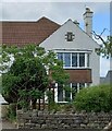
Leeds, 15 Alwoodley Lane
According to the OS benchmark database there is a benchmark cut into the north-east face of the house. The location couldn't be seen from the roadside because of garden shrubs. It is unknown if the cutmark survives.
Image: © Mel Towler
Taken: 14 Jul 2022
0.08 miles