IMAGES TAKEN NEAR TO
Nursery Lane, LEEDS, LS17 7HN
Introduction
This page details the photographs taken nearby to Nursery Lane, LS17 7HN by members of the Geograph project.
The Geograph project started in 2005 with the aim of publishing, organising and preserving representative images for every square kilometre of Great Britain, Ireland and the Isle of Man.

There are currently over 7.5m images from over14,400 individuals and you can help contribute to the project by visiting https://www.geograph.org.uk
Image Map (Loading...)


Getting Data...Please wait
Leaflet Map data © OpenStreetMap
Images are licensed for reuse under creativecommons.org/licenses/by-sa/2.0
Notes
- Clicking on the map will re-center to the selected point.
- The higher the marker number, the further away the image location is from the centre of the postcode.
Image Listing (84 Images Found)
Images are licensed for reuse under creativecommons.org/licenses/by-sa/2.0
Image
Details
Distance
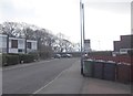
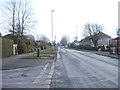
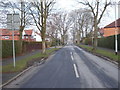
2
Nursery Lane - viewed from Primley Park Crescent
Image: © Betty Longbottom
Taken: 18 Feb 2013
0.06 miles
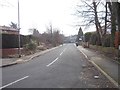
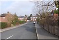
3
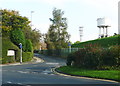
Nursery Lane at Primley Park Crescent, Alwoodley
The embankment is a covered reservoir.
Image: © Humphrey Bolton
Taken: 15 Oct 2016
0.08 miles
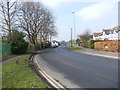
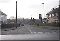
4
Primley Park Crescent - viewed from Nursery Lane
Image: © Betty Longbottom
Taken: 18 Feb 2013
0.08 miles
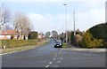
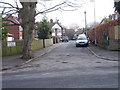
5
Nursery Lane - viewed from Primley Park Road
Image: © Betty Longbottom
Taken: 18 Feb 2013
0.08 miles
7
Primley Park Crescent - Primley Park Avenue
Image: © Betty Longbottom
Taken: 18 Feb 2013
0.09 miles
8
Primley Gardens - Primley Park Road
Image: © Betty Longbottom
Taken: 18 Feb 2013
0.10 miles
10
Hawk's Nest Gardens South - Primley Park Avenue
Image: © Betty Longbottom
Taken: 18 Feb 2013
0.11 miles