IMAGES TAKEN NEAR TO
Street Lane, LEEDS, LS17 6HQ
Introduction
This page details the photographs taken nearby to Street Lane, LS17 6HQ by members of the Geograph project.
The Geograph project started in 2005 with the aim of publishing, organising and preserving representative images for every square kilometre of Great Britain, Ireland and the Isle of Man.

There are currently over 7.5m images from over14,400 individuals and you can help contribute to the project by visiting https://www.geograph.org.uk
Image Map (Loading...)


Getting Data...Please wait
Leaflet Map data © OpenStreetMap
Images are licensed for reuse under creativecommons.org/licenses/by-sa/2.0
Notes
- Clicking on the map will re-center to the selected point.
- The higher the marker number, the further away the image location is from the centre of the postcode.
Image Listing (123 Images Found)
Images are licensed for reuse under creativecommons.org/licenses/by-sa/2.0
Image
Details
Distance
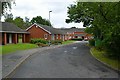
3
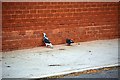
The Green, Roundhay, Leeds
The Pigeon seemed to be eating the house
Image: © Mark Stevenson
Taken: 2 Sep 2016
0.04 miles

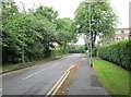
5
Lime Tree Avenue, Moortown
Looking from the end of Allerton Grove towards Street Lane.
Image: © Richard Vince
Taken: 18 Feb 2017
0.05 miles
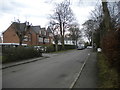
7
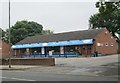
Marlows Fish & Chip Shop - Street Lane
Image: © Betty Longbottom
Taken: 21 Jun 2013
0.06 miles
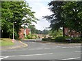
8
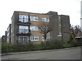
Windsor Court, Moortown
At the east end of Allerton Grove.
Image: © Richard Vince
Taken: 18 Feb 2017
0.06 miles
9
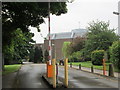
Driveway to Beth Hamidrash Hagadol - Street Lane
Image: © Betty Longbottom
Taken: 21 Jun 2013
0.07 miles
