IMAGES TAKEN NEAR TO
Whinbrook Court, LEEDS, LS17 5PW
Introduction
This page details the photographs taken nearby to Whinbrook Court, LS17 5PW by members of the Geograph project.
The Geograph project started in 2005 with the aim of publishing, organising and preserving representative images for every square kilometre of Great Britain, Ireland and the Isle of Man.

There are currently over 7.5m images from over14,400 individuals and you can help contribute to the project by visiting https://www.geograph.org.uk
Image Map (Loading...)


Getting Data...Please wait
Leaflet Map data © OpenStreetMap
Images are licensed for reuse under creativecommons.org/licenses/by-sa/2.0
Notes
- Clicking on the map will re-center to the selected point.
- The higher the marker number, the further away the image location is from the centre of the postcode.
Image Listing (87 Images Found)
Images are licensed for reuse under creativecommons.org/licenses/by-sa/2.0
Image
Details
Distance
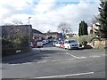
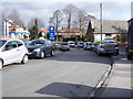
4
Bracken Court - Bracken Hill, King Lane
Image: © Betty Longbottom
Taken: 6 Feb 2013
0.05 miles
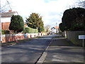
6
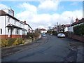
Whinbrook Crescent - Scott Hall Road
Image: © Betty Longbottom
Taken: 6 Feb 2013
0.05 miles
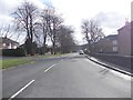
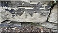
8
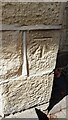
Benchmark on #65 King Lane
Ordnance Survey cut mark benchmark levelled at 126.126m above Newlyn Datum verified 1957
Image: © Roger Templeman
Taken: 10 Aug 2023
0.07 miles
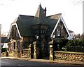
9
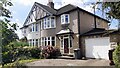
#65 King Lane
There is an Ordnance Survey benchmark Image on the near corner of the house
Image: © Roger Templeman
Taken: 10 Aug 2023
0.07 miles
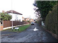
10
Benchmark on stone in wall at junction of Woodbourne Avenue and Scott Hall Road
Ordnance Survey cut mark benchmark levelled at 122.298m above Newlyn Datum verified 1957
Image: © Roger Templeman
Taken: 10 Aug 2023
0.07 miles