IMAGES TAKEN NEAR TO
West Lea Drive, LEEDS, LS17 5BZ
Introduction
This page details the photographs taken nearby to West Lea Drive, LS17 5BZ by members of the Geograph project.
The Geograph project started in 2005 with the aim of publishing, organising and preserving representative images for every square kilometre of Great Britain, Ireland and the Isle of Man.

There are currently over 7.5m images from over14,400 individuals and you can help contribute to the project by visiting https://www.geograph.org.uk
Image Map
Images are licensed for reuse under creativecommons.org/licenses/by-sa/2.0
Notes
- Clicking on the map will re-center to the selected point.
- The higher the marker number, the further away the image location is from the centre of the postcode.
Image Listing (68 Images Found)
Images are licensed for reuse under creativecommons.org/licenses/by-sa/2.0
Image
Details
Distance
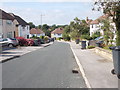
1
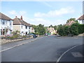
West Lea Drive - looking towards Stonegate Road
Image: © Betty Longbottom
Taken: 3 Sep 2012
0.01 miles
3
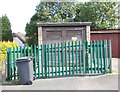
Electricity Substation No 1574 - West Lea Drive
Image: © Betty Longbottom
Taken: 3 Sep 2012
0.03 miles
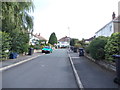
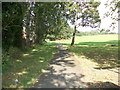
5
West Lea Gardens - looking towards Carr Manor Crescent
Image: © Betty Longbottom
Taken: 3 Sep 2012
0.05 miles
6
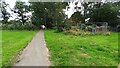
Footpath from Tunnel How Hill approaching Stonegate Road at King Alfred's Green
A collapsed wall is fenced off on right hand side of the path
Image: © Luke Shaw
Taken: 10 Aug 2023
0.06 miles
8
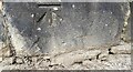
Benchmark on SW end of wall of #245 Stonegate Road at entrance to #205
Ordnance Survey cut mark benchmark levelled at 116.571m above Newlyn Datum verified 1949
Image: © Roger Templeman
Taken: 10 Aug 2023
0.07 miles
9
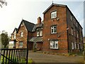
Former Meanwood Convalescent Home, Stonebeck Road
Two discreet lozenge-shaped plaques give the build date as 1879. It has now been converted into eight flats - from the appearance, this is a "house in multiple occupation" rather than "luxury apartments". Not listed.
Image: © Stephen Craven
Taken: 7 Nov 2020
0.07 miles
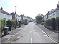
10
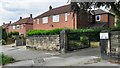
Houses on NW side of Stonegate Road viewed from entrance gateway to #245
There is an Ordnance Survey benchmark Image on the left hand end of the stone wall at the entrance to #205
Image: © Roger Templeman
Taken: 10 Aug 2023
0.07 miles