IMAGES TAKEN NEAR TO
Harrogate Road, LEEDS, LS17 0EY
Introduction
This page details the photographs taken nearby to Harrogate Road, LS17 0EY by members of the Geograph project.
The Geograph project started in 2005 with the aim of publishing, organising and preserving representative images for every square kilometre of Great Britain, Ireland and the Isle of Man.

There are currently over 7.5m images from over14,400 individuals and you can help contribute to the project by visiting https://www.geograph.org.uk
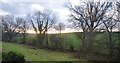
Image Map (Loading...)


Getting Data...Please wait
Leaflet Map data © OpenStreetMap
Images are licensed for reuse under creativecommons.org/licenses/by-sa/2.0
Notes
- Clicking on the map will re-center to the selected point.
- The higher the marker number, the further away the image location is from the centre of the postcode.
Image Listing (33 Images Found)
Images are licensed for reuse under creativecommons.org/licenses/by-sa/2.0
Image
Details
Distance
1
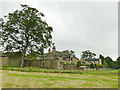
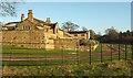
Newby Manor
The name and appearance of this house suggest a considerable age, but only the farther building is shown on the 1908 OS map, named as Newby Cottage, suggesting that the 'manor' itself is a 20th century creation in traditional style. See also Image
Image: © Stephen Craven
Taken: 13 Jun 2020
0.01 miles
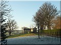
2
Newby Manor
A large property seen from bridleway 15 140/12/1.
Image: © Derek Harper
Taken: 29 Dec 2016
0.02 miles
3
Newby Manor
Bridleway 15 140/12/1 runs past the front of this large house. Frost persists.
Image: © Derek Harper
Taken: 29 Dec 2016
0.02 miles
4
Newby Manor
From bridleway 15 140/12/1 which runs close to the front of the main building. Records go back to the C15 but I think the fabric of the house is much later.
Image: © Derek Harper
Taken: 29 Dec 2016
0.02 miles
5
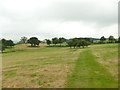
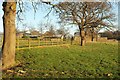
Bridleway below Newby Manor
The right of way runs through private parkland, indicated by a closely mown strip.
Image: © Stephen Craven
Taken: 13 Jun 2020
0.03 miles
6
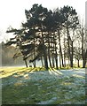
Trees by Newby Manor
From the bridleway in front of Image], looking in the opposite direction to a clump of (mostly) pine trees. Behind is a thick belt of trees bordering the A658 Harrogate Road.
Image: © Derek Harper
Taken: 29 Dec 2016
0.05 miles
7
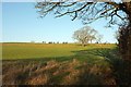
Sheep pasture near Newby
From bridleway 15 140/12/1 at the southern edge of the square.
Image: © Derek Harper
Taken: 29 Dec 2016
0.08 miles
8
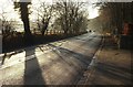
A658 at Newby
From the entrance to Newby Manor and the start of bridleway 15 140/12/1.
Image: © Derek Harper
Taken: 29 Dec 2016
0.11 miles
9
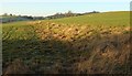
Sheep pasture near Newby
Looking left from the same spot as Image The mapped line of bridleway 15 140/12/1 crosses diagonally towards the lower edge of the field and then back towards the farm buildings on Gravelly Hill. Round Hill is on the horizon, right of centre, behind trees.
Image: © Derek Harper
Taken: 29 Dec 2016
0.14 miles