IMAGES TAKEN NEAR TO
Moor Road, LEEDS, LS16 9HJ
Introduction
This page details the photographs taken nearby to Moor Road, LS16 9HJ by members of the Geograph project.
The Geograph project started in 2005 with the aim of publishing, organising and preserving representative images for every square kilometre of Great Britain, Ireland and the Isle of Man.

There are currently over 7.5m images from over14,400 individuals and you can help contribute to the project by visiting https://www.geograph.org.uk
Image Map
Images are licensed for reuse under creativecommons.org/licenses/by-sa/2.0
Notes
- Clicking on the map will re-center to the selected point.
- The higher the marker number, the further away the image location is from the centre of the postcode.
Image Listing (92 Images Found)
Images are licensed for reuse under creativecommons.org/licenses/by-sa/2.0
Image
Details
Distance
2
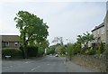
Old Forge Mews, Old Lane, Bramhope
Old maps show a forge (or rather, smithy which is much the same) on the other side of Moor Road, so the name doesn't imply that these modern houses occupy the same site.
Image: © Stephen Craven
Taken: 28 Dec 2020
0.05 miles
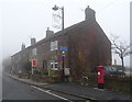
3
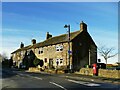
Old Lane, Bramhope
The building nearest the camera, The Hollies, is grade II listed (list entry 1253380) where it is described as a converted 18th century farmhouse. See Image for a close look at the postbox.
Image: © Stephen Craven
Taken: 25 Dec 2020
0.05 miles
4
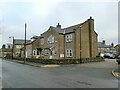
Fox & Hounds, Bramhope
The Cross in the middle of the crossroads was erected in about 1876
Image: © John Armitstead
Taken: 1 Jul 2007
0.06 miles
5
Terraced housing on Old Lane, Bramhope
Postbox No. LS16 91.
See Image] for postbox.
Image: © JThomas
Taken: 23 Nov 2018
0.06 miles
6
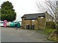
Public toilets in Bramhope
Few villages of this size still have such a facility, unless they are well known tourist spots, which Bramhope isn't. They are in the car park off Old Lane, next to the recycling bins.
Image: © Stephen Craven
Taken: 28 Dec 2020
0.06 miles
7
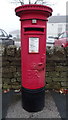
Elizabeth II postbox on Old Lane, Bramhope
Postbox No. LS16 91.
See Image] for context.
Image: © JThomas
Taken: 23 Nov 2018
0.06 miles
8
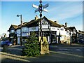
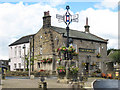
Bramhope Cross
According to another contributor Image the metal cross was erected c.1876. On this occasion (Christmas Day) there was a Christmas tree adjacent to it, but undecorated.
Image: © Stephen Craven
Taken: 25 Dec 2020
0.06 miles
9
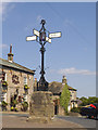
The cross in Bramhope
An unusual and elaborate signpost at the centre of the crossroads. The four roads radiating here are Church Hill (signed to Otley), Old Lane (to Bradford), Moor Road (to Cookridge) and Eastgate (towards Leeds).
Image: © Stephen Craven
Taken: 19 May 2018
0.06 miles
10
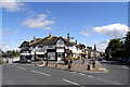
The junction of Church Hill and Eastgate, Bramhope
Image: © habiloid
Taken: 24 Aug 2008
0.07 miles