IMAGES TAKEN NEAR TO
Church Lane, LEEDS, LS16 8BU
Introduction
This page details the photographs taken nearby to Church Lane, LS16 8BU by members of the Geograph project.
The Geograph project started in 2005 with the aim of publishing, organising and preserving representative images for every square kilometre of Great Britain, Ireland and the Isle of Man.

There are currently over 7.5m images from over14,400 individuals and you can help contribute to the project by visiting https://www.geograph.org.uk
Image Map
Images are licensed for reuse under creativecommons.org/licenses/by-sa/2.0
Notes
- Clicking on the map will re-center to the selected point.
- The higher the marker number, the further away the image location is from the centre of the postcode.
Image Listing (68 Images Found)
Images are licensed for reuse under creativecommons.org/licenses/by-sa/2.0
Image
Details
Distance
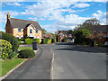
1
Adel Lane - viewed from Church Lane
Image: © Betty Longbottom
Taken: 13 Apr 2012
0.03 miles
2

Electricity Substation No 7669 - Church Lane
Image: © Betty Longbottom
Taken: 13 Apr 2012
0.03 miles
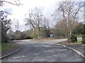
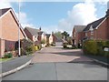
4

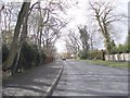
Church Lane, Adel, Leeds
Looking west towards the traffic lights at the junction of Otley Road and Farrar Lane.
Image: © Rich Tea
Taken: 25 Jan 2006
0.05 miles
6
Mile Stone
This stone shows the distance to many well known places in Leeds in miles and furlongs. There is still some lead left in the letter grooves.
Image: © vad falcone
Taken: 6 Oct 2007
0.06 miles
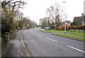
8
Sadler Way, off Church Lane, Adel
Hedges and other greenery have grown considerably since a previous version of this view 12 years earlier Image
Image: © Stephen Craven
Taken: 27 Apr 2020
0.06 miles
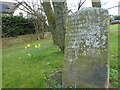
9

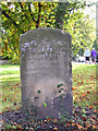
Old Milestone, A660, Otley Road/Church Lane
Located on the South side of road, South side of road Church Lane nr traffic lights. Carved stone post, Leeds Detail stone design, 19th century.
Inscription reads: M. F. / ADEL BRIDGE (6) / ALWOODLEY (GAT)ES 3. / ECCUP BRIDGE 3. / WEARDLEY ( 3. 4 ) / HAREWOOD (HOUSE) 5. 2. / HARROGATE 11. 2. / TINSHILL +(1) / CARR BRIDGE STATION (2) / HORSFORTH CHURCH (3) / RAWDON CHURCH 3. 4. / YEADON CHURCH 5.
Milestone Society National ID: YW_LEOT05c
Image: © Christine Minto
Taken: 30 Jan 2006
0.06 miles
10
Old milestone
On the southeast corner of Church Lane with the A660 is the tallest of this style of milestone. Although leaning it is 117cm tall. As well as distances to bridges and churches this has 3 miles to Alwoodley Gates, Harewood House 5M2F and Carr Bridge Station 2. This shows that these stones must have been set up before the end of the turnpike era but after the railways began running.
Image: © Chris Minto
Taken: 19 Mar 2023
0.06 miles