IMAGES TAKEN NEAR TO
Eccup Lane, LEEDS, LS16 8AT
Introduction
This page details the photographs taken nearby to Eccup Lane, LS16 8AT by members of the Geograph project.
The Geograph project started in 2005 with the aim of publishing, organising and preserving representative images for every square kilometre of Great Britain, Ireland and the Isle of Man.

There are currently over 7.5m images from over14,400 individuals and you can help contribute to the project by visiting https://www.geograph.org.uk
Image Map
Images are licensed for reuse under creativecommons.org/licenses/by-sa/2.0
Notes
- Clicking on the map will re-center to the selected point.
- The higher the marker number, the further away the image location is from the centre of the postcode.
Image Listing (24 Images Found)
Images are licensed for reuse under creativecommons.org/licenses/by-sa/2.0
Image
Details
Distance
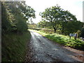
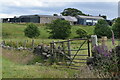
2
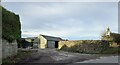
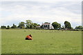
Eccup, Brookland Farm
According to the 1908 OS map there was a benchmark at the farm entrance, possibly a gatepost. Nothing was found.
Image: © Mel Towler
Taken: 5 Feb 2023
0.02 miles
9
Arthington: The 'New Inn'
Seen across the fields containing sheep and kyce*
*An old Yorkshire word for 'cattle'
Image: © Dr Neil Clifton
Taken: 4 Jun 2017
0.21 miles
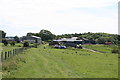
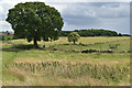
10
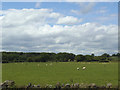
Sheep in a field by Eccup Lane
They are grazing flat land near the top of the scarp slope of Wharfedale. The Dales Way link passes along the far edge of their field.
Image: © Stephen Craven
Taken: 23 Jun 2020
0.21 miles