IMAGES TAKEN NEAR TO
Holt Lane, LEEDS, LS16 7NX
Introduction
This page details the photographs taken nearby to Holt Lane, LS16 7NX by members of the Geograph project.
The Geograph project started in 2005 with the aim of publishing, organising and preserving representative images for every square kilometre of Great Britain, Ireland and the Isle of Man.

There are currently over 7.5m images from over14,400 individuals and you can help contribute to the project by visiting https://www.geograph.org.uk
Image Map
Images are licensed for reuse under creativecommons.org/licenses/by-sa/2.0
Notes
- Clicking on the map will re-center to the selected point.
- The higher the marker number, the further away the image location is from the centre of the postcode.
Image Listing (73 Images Found)
Images are licensed for reuse under creativecommons.org/licenses/by-sa/2.0
Image
Details
Distance
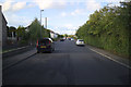
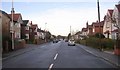
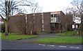
3
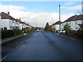
Gainsborough Drive, Adel
Well established residential road off Holt Lane on the northern fringes of the suburbs of Leeds
Image: © Chris Heaton
Taken: 18 Oct 2012
0.03 miles
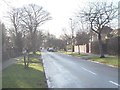
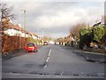
7
Whinfield approaching Holt Lane, Adel Leeds
Looking northward.
Image: © Peter Wood
Taken: 1 Aug 2018
0.06 miles
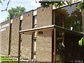
9
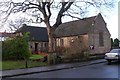
Adel Methodist Church Hall - Gainsbro Avenue
Image: © Betty Longbottom
Taken: 15 Jan 2008
0.07 miles