IMAGES TAKEN NEAR TO
Spen Lane, LEEDS, LS16 6JQ
Introduction
This page details the photographs taken nearby to Spen Lane, LS16 6JQ by members of the Geograph project.
The Geograph project started in 2005 with the aim of publishing, organising and preserving representative images for every square kilometre of Great Britain, Ireland and the Isle of Man.

There are currently over 7.5m images from over14,400 individuals and you can help contribute to the project by visiting https://www.geograph.org.uk
Image Map
Images are licensed for reuse under creativecommons.org/licenses/by-sa/2.0
Notes
- Clicking on the map will re-center to the selected point.
- The higher the marker number, the further away the image location is from the centre of the postcode.
Image Listing (72 Images Found)
Images are licensed for reuse under creativecommons.org/licenses/by-sa/2.0
Image
Details
Distance
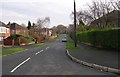
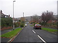
3
Houses on Wynford Mount at Spen Lane junction
Image: © Luke Shaw
Taken: 6 May 2023
0.04 miles
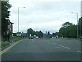
4
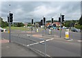
Traffic lights, Leeds ring road
At the junction of the A6120 with Spen Lane (left and right), at West Park.
Image: © Derek Harper
Taken: 15 Jun 2011
0.06 miles
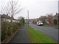
5

Parkstone Avenue - West Park Ring Road
Image: © Betty Longbottom
Taken: 12 Sep 2011
0.08 miles
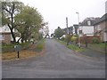
7
Wynford Avenue - Ring Road, West Park
Image: © Betty Longbottom
Taken: 14 Nov 2011
0.10 miles
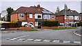
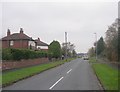
10
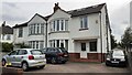
Nos. 3 and 5 Ring Road
Ordnance Survey documents indicate that a benchmark levelled at 122.207m above Newlyn Datum was verified in 1957 on the side of the right hand house at its front corner
Image: © Roger Templeman
Taken: 6 May 2023
0.12 miles