
IMAGES TAKEN NEAR TO
Oak Park Lane, LEEDS, LS16 6FF
Introduction
This page details the photographs taken nearby to Oak Park Lane, LS16 6FF by members of the Geograph project.
The Geograph project started in 2005 with the aim of publishing, organising and preserving representative images for every square kilometre of Great Britain, Ireland and the Isle of Man.

There are currently over 7.5m images from over14,400 individuals and you can help contribute to the project by visiting https://www.geograph.org.uk
Image Map
Images are licensed for reuse under creativecommons.org/licenses/by-sa/2.0
Notes
- Clicking on the map will re-center to the selected point.
- The higher the marker number, the further away the image location is from the centre of the postcode.
Image Listing (83 Images Found)
Images are licensed for reuse under creativecommons.org/licenses/by-sa/2.0
Image
Details
Distance
1
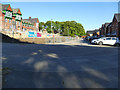
Oak Park Lane
The housing estate has been built in recent years in the grounds of the former Cookridge Hospital and this spine road follows the alignment of one of the original hospital access roads. The main hospital building can be seen to the left, and is currently being converted.
Image: © Stephen Craven
Taken: 15 May 2020
0.01 miles
2
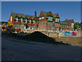
The former Cookridge Hospital
Cookridge was a convalescent hospital built in 1868, architect Norman Shaw, with the east wing added in 1893. Since it closed a housing estate has been built in the grounds and work is now in progress converting the old building to apartments. It is listed grade II (list entry 1255595).
Image: © Stephen Craven
Taken: 15 May 2020
0.04 miles
3
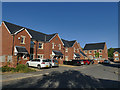
Oak Park Drive
The housing estate has been built in recent years in the grounds of the former Cookridge Hospital. Although it is well served by buses, and within walking distance of Horsforth railway station, disappointingly every house seemed to have at least one car parked outside.
Image: © Stephen Craven
Taken: 15 May 2020
0.04 miles
4
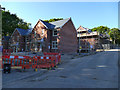
New housing on the Oak Park estate
The housing estate has been built in recent years in the grounds of the former Cookridge Hospital and construction is still in progress on the latest phase.
Image: © Stephen Craven
Taken: 15 May 2020
0.04 miles
5
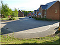
Housing on Oak Park Lane
The housing estate has been built in recent years in the grounds of the former Cookridge Hospital. This is the new entrance to the estate from Silk Mill Way.
Image: © Stephen Craven
Taken: 15 May 2020
0.05 miles
6
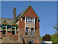
The former Cookridge Hospital - Jackson Wing
Cookridge hospital Image was a convalescent hospital built in 1868, architect Norman Shaw, with this east wing added later. The name "The Edward Jackson Memorial Wing 1893" can be seen inscribed in the stonework. Work is now in progress converting the old building to apartments. It is listed grade II (list entry 1255595).
Image: © Stephen Craven
Taken: 15 May 2020
0.05 miles
7
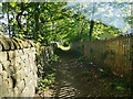
Footpath to Silk Mill Way
A public footpath running down the side of what was formerly Cookridge Hospital but is now a private housing estate. The smoke to the right is from a garden bonfire.
Image: © Stephen Craven
Taken: 15 May 2020
0.06 miles
8
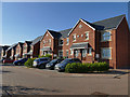
Oak Park Terrace
The housing estate has been built in recent years in the grounds of the former Cookridge Hospital. This is a modern interpretation of terraced housing, very different from the traditional "coal hole and privy" image.
Image: © Stephen Craven
Taken: 15 May 2020
0.06 miles
10
Bus stops on Silk Mill Way
The one on the left (for passengers heading towards the city centre) has a shelter and layby; the one on the right (probably used mainly for alighting) does not.
Image: © Stephen Craven
Taken: 15 May 2020
0.07 miles