IMAGES TAKEN NEAR TO
Huntington Crescent, LEEDS, LS16 5RT
Introduction
This page details the photographs taken nearby to Huntington Crescent, LS16 5RT by members of the Geograph project.
The Geograph project started in 2005 with the aim of publishing, organising and preserving representative images for every square kilometre of Great Britain, Ireland and the Isle of Man.

There are currently over 7.5m images from over14,400 individuals and you can help contribute to the project by visiting https://www.geograph.org.uk
Image Map
Images are licensed for reuse under creativecommons.org/licenses/by-sa/2.0
Notes
- Clicking on the map will re-center to the selected point.
- The higher the marker number, the further away the image location is from the centre of the postcode.
Image Listing (109 Images Found)
Images are licensed for reuse under creativecommons.org/licenses/by-sa/2.0
Image
Details
Distance
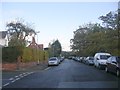
1
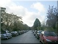
Ancaster Road - viewed from Welburn Avenue
Image: © Betty Longbottom
Taken: 1 Nov 2011
0.04 miles
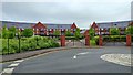
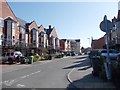
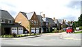
3
Huntington Crescent
New development built on site of water treatment works & reservoir.
Image: © Betty Longbottom
Taken: 31 Aug 2007
0.04 miles
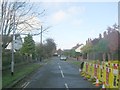
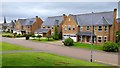
5

Huntington Crescent - Thornbury Avenue
Image: © Betty Longbottom
Taken: 6 Mar 2012
0.05 miles
6
Ancaster Road - viewed from Welburn Avenue
Image: © Betty Longbottom
Taken: 1 Nov 2011
0.06 miles
7
Montgomery Avenue - Thornbury Avenue
Image: © Betty Longbottom
Taken: 6 Mar 2012
0.06 miles
9
Carisbrooke Road - Thornbury Avenue
Image: © Betty Longbottom
Taken: 6 Mar 2012
0.07 miles
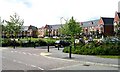
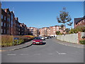
10
Fulton Place
New development built on site of water treatment works & reservoir.
Image: © Betty Longbottom
Taken: 31 Aug 2007
0.07 miles