IMAGES TAKEN NEAR TO
Spen Mews, LEEDS, LS16 5QN
Introduction
This page details the photographs taken nearby to Spen Mews, LS16 5QN by members of the Geograph project.
The Geograph project started in 2005 with the aim of publishing, organising and preserving representative images for every square kilometre of Great Britain, Ireland and the Isle of Man.

There are currently over 7.5m images from over14,400 individuals and you can help contribute to the project by visiting https://www.geograph.org.uk
Image Map
Images are licensed for reuse under creativecommons.org/licenses/by-sa/2.0
Notes
- Clicking on the map will re-center to the selected point.
- The higher the marker number, the further away the image location is from the centre of the postcode.
Image Listing (106 Images Found)
Images are licensed for reuse under creativecommons.org/licenses/by-sa/2.0
Image
Details
Distance
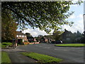
1
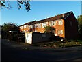
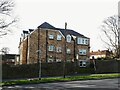
Spen Mews
A row of houses built within the grounds of Westbury Gardens.
Image: © Stephen Craven
Taken: 28 Apr 2021
0.01 miles
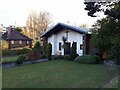
2
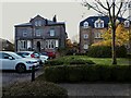
Westbury Gardens, original house
The older property in this development (left) is shown as Spen Hill on older maps, and before that as "Abbey View". It is now described on an estate agent's website as "a period manor house that has been lovingly converted into professional apartments".
Image: © Stephen Craven
Taken: 28 Apr 2021
0.01 miles
3
Catholic Church of the Assumption of Our Lady - Spen Lane
Image: © Betty Longbottom
Taken: 22 Jan 2008
0.03 miles
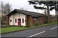
4
Church of the Assumption of Our Lady - hall to rear
See Image for the front of the church.
Image: © Stephen Craven
Taken: 28 Apr 2021
0.03 miles
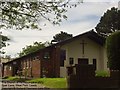
5
Westbury Gardens
On the site of the former Spen Lane Farm.
Image: © Stephen Craven
Taken: 22 Mar 2021
0.03 miles
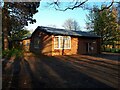
6
Church of the Assumption of Our Lady, Spen Lane
A modest sized Roman Catholic church, built in 1957 and refurbished in 2012. For a more detailed history see the parish website http://www.ourladyofkirkstall.org.uk/The_assumptionhistory.html
Image: © Stephen Craven
Taken: 28 Apr 2021
0.04 miles
7
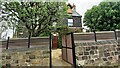
Spen House on west side of Spen Lane
There is an Ordnance Survey benchmark Image on the right hand face of the house
Image: © Roger Templeman
Taken: 6 May 2023
0.05 miles
8
The Church of the Assumption (RC), Spen Lane, Leeds
Image: © Rich Tea
Taken: Unknown
0.05 miles
10
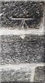
Benchmark on north face of Spen House, #241 Spen Lane
Ordnance Survey cut mark benchmark levelled at 108.296m above Newlyn Datum verified 1957
Image: © Roger Templeman
Taken: 6 May 2023
0.06 miles