IMAGES TAKEN NEAR TO
Edgerton Road, LEEDS, LS16 5JD
Introduction
This page details the photographs taken nearby to Edgerton Road, LS16 5JD by members of the Geograph project.
The Geograph project started in 2005 with the aim of publishing, organising and preserving representative images for every square kilometre of Great Britain, Ireland and the Isle of Man.

There are currently over 7.5m images from over14,400 individuals and you can help contribute to the project by visiting https://www.geograph.org.uk
Image Map
Images are licensed for reuse under creativecommons.org/licenses/by-sa/2.0
Notes
- Clicking on the map will re-center to the selected point.
- The higher the marker number, the further away the image location is from the centre of the postcode.
Image Listing (125 Images Found)
Images are licensed for reuse under creativecommons.org/licenses/by-sa/2.0
Image
Details
Distance
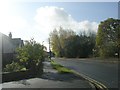
2
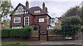
#2 Edgerton Road
Ordnance Survey documents indicate that a benchmark levelled at 113.419m above Newlyn Datum was verified in 1957 on the right hand side of the house at its front corner
Image: © Roger Templeman
Taken: 6 May 2023
0.01 miles
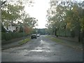
4
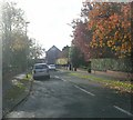
Spen Road - viewed from West Park Drive
Image: © Betty Longbottom
Taken: 1 Nov 2011
0.03 miles
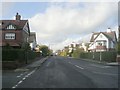
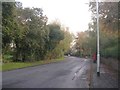
7
Welburn Avenue - viewed from Northolme Avenue
Image: © Betty Longbottom
Taken: 1 Nov 2011
0.04 miles