IMAGES TAKEN NEAR TO
Spen Drive, LEEDS, LS16 5AH
Introduction
This page details the photographs taken nearby to Spen Drive, LS16 5AH by members of the Geograph project.
The Geograph project started in 2005 with the aim of publishing, organising and preserving representative images for every square kilometre of Great Britain, Ireland and the Isle of Man.

There are currently over 7.5m images from over14,400 individuals and you can help contribute to the project by visiting https://www.geograph.org.uk
Image Map
Images are licensed for reuse under creativecommons.org/licenses/by-sa/2.0
Notes
- Clicking on the map will re-center to the selected point.
- The higher the marker number, the further away the image location is from the centre of the postcode.
Image Listing (94 Images Found)
Images are licensed for reuse under creativecommons.org/licenses/by-sa/2.0
Image
Details
Distance
2
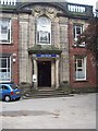
Lawnswood School, West Building, Leeds
This photo was taken on the open day, 6 July 2003. This was held at the end of the last year in the old school buildings. The school moved into a new building on the same site in September 2003 and the old buildings were demolished.
Image: © Rich Tea
Taken: 6 Jul 2003
0.03 miles
3
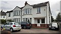
Nos. 3 and 5 Ring Road
Ordnance Survey documents indicate that a benchmark levelled at 122.207m above Newlyn Datum was verified in 1957 on the side of the right hand house at its front corner
Image: © Roger Templeman
Taken: 6 May 2023
0.04 miles
4
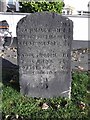
Old Milestone by Spen Road, West Park, Leeds
Carved stone post by the UC road, in parish of LEEDS (LEEDS District), West Park, Spen Road, junction with Spen Lane, on North side of road, on grass patch in pavement in front of #24. Leeds detail stone, erected by the Leeds & Otley turnpike trust in the 19th century.
Inscription reads:-
: M.F./ KIRKSTALL BRIDGE (?) / HORSFORTH BRIDGE 1.6. / RAWDON CHURCH 3.6. : : M.F. / HEADINGLEY CHURCH 1.2 / WOODHOUSE MOOR 1.6 / LEEDS BRIDGE 2.6 / ADEL CHURCH 1.7 / POOL BANK 5 / OTLEY CHURCH 7.6 / ARTHINGTON STATION 5.1 :
Cancelled benchmark on front base.
Milestone Society National ID: YW_LEOT03a.
Image: © C Minto
Taken: 22 Jul 2004
0.05 miles
5

Old milestone
At the junction of Spen Lane with Spen Road in West Park is the chunky informative milestone. The left face is inscribed:-
M.F./KIRKSTALL BRIDGE (?)/HORSFORTH BRIDGE 1.6./RAWDON CHURCH 3.6. The stone is 58cm wide, 48cm deep and 95cm tall.
Milestone Society ID - YW_LEOT03a
Image: © Chris Minto
Taken: 6 Sep 2025
0.05 miles
6
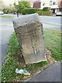
Spen Lane milestone - side
The inscription is more clearly visible on this side, with distances in miles and furlongs to Kirkstall Bridge, Horsforth Bridge and Rawdon Church. See Image for the front.
Image: © Stephen Craven
Taken: 28 Apr 2021
0.05 miles
7
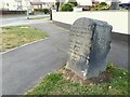
Spen Lane milestone - front
The inscription can be seen more clearly, and is transcribed, in the photo from the Milestone Society Image where it is also attributed to the Leeds & Otley Turnpike Trust.
Image: © Stephen Craven
Taken: 28 Apr 2021
0.05 miles