IMAGES TAKEN NEAR TO
Boundary Close, LEEDS, LS15 9HX
Introduction
This page details the photographs taken nearby to Boundary Close, LS15 9HX by members of the Geograph project.
The Geograph project started in 2005 with the aim of publishing, organising and preserving representative images for every square kilometre of Great Britain, Ireland and the Isle of Man.

There are currently over 7.5m images from over14,400 individuals and you can help contribute to the project by visiting https://www.geograph.org.uk
Image Map
Images are licensed for reuse under creativecommons.org/licenses/by-sa/2.0
Notes
- Clicking on the map will re-center to the selected point.
- The higher the marker number, the further away the image location is from the centre of the postcode.
Image Listing (58 Images Found)
Images are licensed for reuse under creativecommons.org/licenses/by-sa/2.0
Image
Details
Distance
1
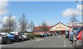
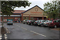
Sainsbury's, Colton Retail Park
On a sunny lunchtime. An awful queue to get out of the car park - took 10 minutes.
Image: © Rich Tea
Taken: 13 Apr 2006
0.05 miles
4
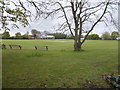
Colton Institute Cricket Ground - School Lane
Image: © Betty Longbottom
Taken: 6 May 2015
0.08 miles
6
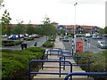
Colton Retail Park
Typical of the retail parks that have appeared over the last two decades on the edges of urban areas, Colton dates from the 1990s. Shops in view here include JJB Sports, Next and Boots.
Image: © Stephen McKay
Taken: 14 Aug 2010
0.10 miles