IMAGES TAKEN NEAR TO
Darnley Lane, LEEDS, LS15 9EY
Introduction
This page details the photographs taken nearby to Darnley Lane, LS15 9EY by members of the Geograph project.
The Geograph project started in 2005 with the aim of publishing, organising and preserving representative images for every square kilometre of Great Britain, Ireland and the Isle of Man.

There are currently over 7.5m images from over14,400 individuals and you can help contribute to the project by visiting https://www.geograph.org.uk
Image Map
Images are licensed for reuse under creativecommons.org/licenses/by-sa/2.0
Notes
- Clicking on the map will re-center to the selected point.
- The higher the marker number, the further away the image location is from the centre of the postcode.
Image Listing (75 Images Found)
Images are licensed for reuse under creativecommons.org/licenses/by-sa/2.0
Image
Details
Distance

5
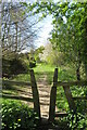
Stile and footpath, Fox Covert
Stile and footpath along edge of Fox Covert, Temple Newsam. Spring 2020
Image: © Oxana Maher
Taken: 19 Apr 2020
0.04 miles

7
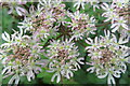
Common hogweed
Attractive flowers of the common hogweed....not the giant variety!
Image: © Oxana Maher
Taken: 19 Oct 2020
0.06 miles

9
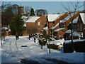
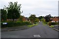
Kirkfield View, Colton Village, Leeds
Snow covered street in Colton with St Mary's Church at Whitkirk in the background.
Image: © John Glasby
Taken: 26 Jan 2013
0.07 miles