IMAGES TAKEN NEAR TO
Hollingbourne Road, LEEDS, LS15 8XG
Introduction
This page details the photographs taken nearby to Hollingbourne Road, LS15 8XG by members of the Geograph project.
The Geograph project started in 2005 with the aim of publishing, organising and preserving representative images for every square kilometre of Great Britain, Ireland and the Isle of Man.

There are currently over 7.5m images from over14,400 individuals and you can help contribute to the project by visiting https://www.geograph.org.uk
Image Map
Images are licensed for reuse under creativecommons.org/licenses/by-sa/2.0
Notes
- Clicking on the map will re-center to the selected point.
- The higher the marker number, the further away the image location is from the centre of the postcode.
Image Listing (47 Images Found)
Images are licensed for reuse under creativecommons.org/licenses/by-sa/2.0
Image
Details
Distance
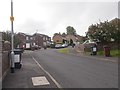
1
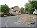
Hollingbourne Road, Penda's Fields
A short stub of a road off Biddenden Road.
Image: © Christine Johnstone
Taken: 25 Jul 2012
0.02 miles

4
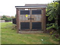
Electricity Substation No 4934 - Smeaton Approach
Image: © Betty Longbottom
Taken: 22 Aug 2015
0.04 miles
5
Kemsing Walk, Penda's Fields
Off Biddenden Road.
Image: © Christine Johnstone
Taken: 25 Jul 2012
0.04 miles
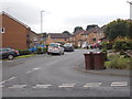
6
Smeaton Approach - viewed from Sandleas Way
Image: © Betty Longbottom
Taken: 22 Aug 2015
0.05 miles
7
Biddenden Road, Penda's Fields [2]
The south side at the western end.
Image: © Christine Johnstone
Taken: 25 Jul 2012
0.05 miles
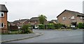
9
Smeaton Approach - viewed from Sandleas Way
Image: © Betty Longbottom
Taken: 22 Aug 2015
0.07 miles
10
Dovedale Gardens - Dovedale Garth
Image: © Betty Longbottom
Taken: 22 Aug 2015
0.08 miles