IMAGES TAKEN NEAR TO
The Avenue, LEEDS, LS15 8JN
Introduction
This page details the photographs taken nearby to The Avenue, LS15 8JN by members of the Geograph project.
The Geograph project started in 2005 with the aim of publishing, organising and preserving representative images for every square kilometre of Great Britain, Ireland and the Isle of Man.

There are currently over 7.5m images from over14,400 individuals and you can help contribute to the project by visiting https://www.geograph.org.uk
Image Map (Loading...)


Getting Data...Please wait
Leaflet Map data © OpenStreetMap
Images are licensed for reuse under creativecommons.org/licenses/by-sa/2.0
Notes
- Clicking on the map will re-center to the selected point.
- The higher the marker number, the further away the image location is from the centre of the postcode.
Image Listing (90 Images Found)
Images are licensed for reuse under creativecommons.org/licenses/by-sa/2.0
Image
Details
Distance
2
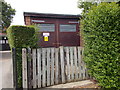
Electricity Substation No 1681 - Kelmscott Lane
Image: © Betty Longbottom
Taken: 15 Jun 2015
0.05 miles
6
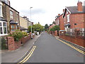
Kelmscott Grove - Kelmscott Avenue
Image: © Betty Longbottom
Taken: 15 Jun 2015
0.07 miles
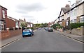
8
Extended semis, Kelmscott Lane, Manston
Two different solutions, probably at vastly different budgets.
Image: © Christine Johnstone
Taken: 25 Jul 2012
0.10 miles
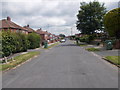
10
Kelmscott Crescent - Kelmscott Green
Image: © Betty Longbottom
Taken: 15 Jun 2015
0.11 miles