IMAGES TAKEN NEAR TO
Manston Lane, LEEDS, LS15 8AD
Introduction
This page details the photographs taken nearby to Manston Lane, LS15 8AD by members of the Geograph project.
The Geograph project started in 2005 with the aim of publishing, organising and preserving representative images for every square kilometre of Great Britain, Ireland and the Isle of Man.

There are currently over 7.5m images from over14,400 individuals and you can help contribute to the project by visiting https://www.geograph.org.uk
Image Map (36 Images)


Getting Data...Please wait
Leaflet Map data © OpenStreetMap
Images are licensed for reuse under creativecommons.org/licenses/by-sa/2.0
Notes
- Clicking on the map will re-center to the selected point.
- The higher the marker number, the further away the image location is from the centre of the postcode.
Image Listing (36 Images Found)
Images are licensed for reuse under creativecommons.org/licenses/by-sa/2.0
Image
Details
Distance
1
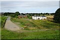
Lazencroft Farm beside Manston Lane
What appears to be a derelict farm, probably awaiting redevelopment into housing along the East Leeds Orbital Route.
Image: © DS Pugh
Taken: 3 Aug 2024
0.01 miles
2
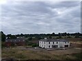
Lazencroft Farm
I don't know what the residents of this property (no longer a working farm) thought of having an elevated bypass built only a hundred metres from their property. See Image for a photo taken several years earlier from a different angle.
As of June 2023 there is a planning application to convert it to a children's nursery.
Image: © Stephen Craven
Taken: 26 Aug 2022
0.02 miles
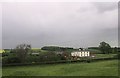
4

Lazencroft Farm
Lazencroft Farm converted for residential use
Image: © Derek Mowbray
Taken: 27 Jun 2012
0.02 miles
6

Trying out the new ELOR cycle route
The new orbital road has been designed with non-motorised users in mind, with a parallel hard-surfaced cycle route all the way along the west side, and a soft-surfaced path for horse riders and mountain bikers on the east side. In the weeks after it opened in August 2022, many cyclists and pedestrians could be seen exploring the new facility.
Image: © Stephen Craven
Taken: 26 Aug 2022
0.06 miles
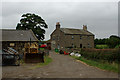
7
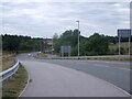
Manston Lane west from the ELOR roundabout
The lane leads towards Cross Gates. There has been minimal realignment of the road on plan but it has been raised up to meet the orbital route as it comes down off William Parkin Bridge.
Image: © Stephen Craven
Taken: 26 Aug 2022
0.06 miles
8

Cycle signage at the Manston Lane roundabout
Signage directs cyclists and pedestrians along Manston lane towards Cross Gates, as well as both ways along the ELOR.
Image: © Stephen Craven
Taken: 26 Aug 2022
0.07 miles
9
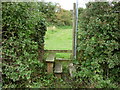
A walk from Oulton Church #36
Over the stile and into the fields.
Image: © Ian S
Taken: 14 Aug 2010
0.07 miles
10
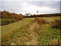
Trackbed of old railway
This is part of the trackbed of the railway that served the old World war 1 munitions factory
Image: © Derek Mowbray
Taken: 1 Nov 2003
0.08 miles