IMAGES TAKEN NEAR TO
Maryfield Gardens, LEEDS, LS15 7TX
Introduction
This page details the photographs taken nearby to Maryfield Gardens, LS15 7TX by members of the Geograph project.
The Geograph project started in 2005 with the aim of publishing, organising and preserving representative images for every square kilometre of Great Britain, Ireland and the Isle of Man.

There are currently over 7.5m images from over14,400 individuals and you can help contribute to the project by visiting https://www.geograph.org.uk
Image Map (Loading...)


Getting Data...Please wait
Leaflet Map data © OpenStreetMap
Images are licensed for reuse under creativecommons.org/licenses/by-sa/2.0
Notes
- Clicking on the map will re-center to the selected point.
- The higher the marker number, the further away the image location is from the centre of the postcode.
Image Listing (44 Images Found)
Images are licensed for reuse under creativecommons.org/licenses/by-sa/2.0
Image
Details
Distance
1
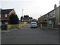
Maryfield Gardens - Maryfield Avenue
Image: © Betty Longbottom
Taken: 2 Feb 2015
0.02 miles
3
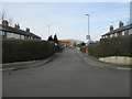
Bridle Path Walk - Maryfield Avenue
Image: © Betty Longbottom
Taken: 2 Feb 2015
0.05 miles
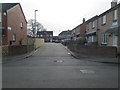
4
Maryfield Avenue - viewed from Bridle Path
Image: © Betty Longbottom
Taken: 2 Feb 2015
0.05 miles
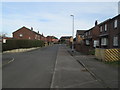
5
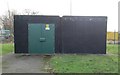
Electricity Substation No 169 - Maryfield Avenue
Image: © Betty Longbottom
Taken: 2 Feb 2015
0.06 miles
6
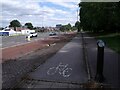
Bus and cycle lanes on Cross Gates Road
The cycle lane soon becomes a shared-use pavement.
Image: © Stephen Craven
Taken: 26 Aug 2022
0.07 miles
7
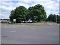
Cross Gates roundabout
A major junction on the A64 out of Leeds, also known as the Oval.
Image: © Stephen Craven
Taken: 26 Aug 2022
0.09 miles
8
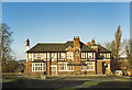
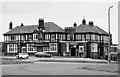
The Melbourne Pub
The Melbourne was demolished around 1989/90. A Burger King 'restaurant' now occupies the site, along with a Halfords store on what used to be the car park.
Image: © Justin Credible
Taken: Unknown
0.10 miles
9
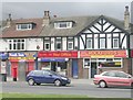
Foundry Lane Post Office & Shops - York Road
Image: © Betty Longbottom
Taken: 22 Jul 2008
0.11 miles
10
The Melbourne Pub
The Melbourne was demolished around 1989/90. A Burger King 'restaurant' now occupies the site, along with a Halfords store on what used to be the car park.
Image: © Justin Credible
Taken: Unknown
0.11 miles