IMAGES TAKEN NEAR TO
Coldwell Square, LEEDS, LS15 7HB
Introduction
This page details the photographs taken nearby to Coldwell Square, LS15 7HB by members of the Geograph project.
The Geograph project started in 2005 with the aim of publishing, organising and preserving representative images for every square kilometre of Great Britain, Ireland and the Isle of Man.

There are currently over 7.5m images from over14,400 individuals and you can help contribute to the project by visiting https://www.geograph.org.uk
Image Map
Images are licensed for reuse under creativecommons.org/licenses/by-sa/2.0
Notes
- Clicking on the map will re-center to the selected point.
- The higher the marker number, the further away the image location is from the centre of the postcode.
Image Listing (181 Images Found)
Images are licensed for reuse under creativecommons.org/licenses/by-sa/2.0
Image
Details
Distance
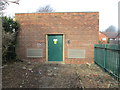
2
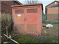
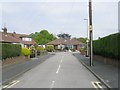
Electricity Substation No 1857 - Cold Well Road
Image: © Betty Longbottom
Taken: 2 Feb 2015
0.03 miles
7
Electricity Substation No 892 - Green Lane
Image: © Betty Longbottom
Taken: 2 Feb 2015
0.08 miles
9
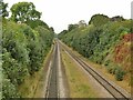
Railway west from Cross Gates station
The large gap between the two remaining tracks reflects that the station once had two through lines between the platform lines. This line will be electrified in the next few years as part of the TransPennine Route Upgrade.
Image: © Stephen Craven
Taken: 30 Sep 2023
0.09 miles