IMAGES TAKEN NEAR TO
Knightsway, LEEDS, LS15 7BW
Introduction
This page details the photographs taken nearby to Knightsway, LS15 7BW by members of the Geograph project.
The Geograph project started in 2005 with the aim of publishing, organising and preserving representative images for every square kilometre of Great Britain, Ireland and the Isle of Man.

There are currently over 7.5m images from over14,400 individuals and you can help contribute to the project by visiting https://www.geograph.org.uk
Image Map (Loading...)


Getting Data...Please wait
Leaflet Map data © OpenStreetMap
Images are licensed for reuse under creativecommons.org/licenses/by-sa/2.0
Notes
- Clicking on the map will re-center to the selected point.
- The higher the marker number, the further away the image location is from the centre of the postcode.
Image Listing (105 Images Found)
Images are licensed for reuse under creativecommons.org/licenses/by-sa/2.0
Image
Details
Distance
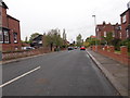
1
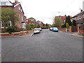
Hollyshaw Grove - looking towards Hollyshaw Lane
Image: © Betty Longbottom
Taken: 6 May 2015
0.04 miles
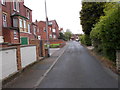
2
Hollyshaw Terrace - Hollyshaw Street
Image: © Betty Longbottom
Taken: 6 May 2015
0.05 miles
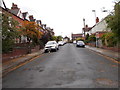
7
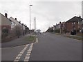
Knightsway - viewed from Carter Avenue
Image: © Betty Longbottom
Taken: 1 Apr 2015
0.10 miles
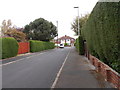
9
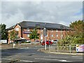
Premier Inn, Whitkirk
With solar panels on the east side.
Image: © Stephen Craven
Taken: 1 Oct 2022
0.11 miles
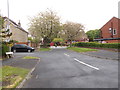
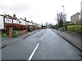
10
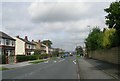
Knightsway - Selby Road, Whitkirk
Image: © Betty Longbottom
Taken: 13 Sep 2008
0.11 miles