IMAGES TAKEN NEAR TO
Baronsmead, LEEDS, LS15 7AR
Introduction
This page details the photographs taken nearby to Baronsmead, LS15 7AR by members of the Geograph project.
The Geograph project started in 2005 with the aim of publishing, organising and preserving representative images for every square kilometre of Great Britain, Ireland and the Isle of Man.

There are currently over 7.5m images from over14,400 individuals and you can help contribute to the project by visiting https://www.geograph.org.uk
Image Map
Images are licensed for reuse under creativecommons.org/licenses/by-sa/2.0
Notes
- Clicking on the map will re-center to the selected point.
- The higher the marker number, the further away the image location is from the centre of the postcode.
Image Listing (110 Images Found)
Images are licensed for reuse under creativecommons.org/licenses/by-sa/2.0
Image
Details
Distance
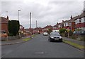
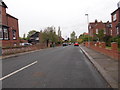
1
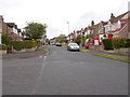
Baronsmead - viewed from Knightshill
Image: © Betty Longbottom
Taken: 6 May 2015
0.02 miles
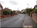
2
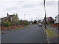
Baronsmead - viewed from Knightshill
Image: © Betty Longbottom
Taken: 6 May 2015
0.04 miles
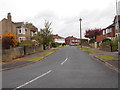
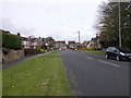
5
Hollyshaw Crescent - viewed from Baronsway
Image: © Betty Longbottom
Taken: 6 May 2015
0.08 miles
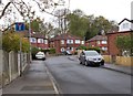
8
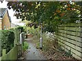
Footpath off Selby Road
The path leads to Gibson Drive. Like many such urban paths it follows an ancient field boundary.
Image: © Stephen Craven
Taken: 1 Oct 2022
0.10 miles
10
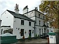
The Grange, Selby Road, Whitkirk
An early 19th century building, now subdivided into apartments but grade II listed (list entry 1256099).
Image: © Stephen Craven
Taken: 1 Oct 2022
0.11 miles